Approximate Location Map
Large Map »
This site is entirely user-supported. See how you can help.
Latitude: 54.2896 / 54°17'22"N
Longitude: -0.5243 / 0°31'27"W
OS Eastings: 496156.392822
OS Northings: 489219.906822
OS Grid: SE961892
Mapcode National: GBR SLSV.92
Mapcode Global: WHGBY.XFJW
Entry Name: Round barrow on Shortgate Noddle, 330m south east of Coomb Slack Farm
Scheduled Date: 4 August 1933
Last Amended: 10 January 2000
Source: Historic England
Source ID: 1017146
English Heritage Legacy ID: 32495
County: North Yorkshire
Civil Parish: Hackness
Traditional County: Yorkshire
Lieutenancy Area (Ceremonial County): North Yorkshire
Church of England Parish: Hackness with Harwood Dale
Church of England Diocese: York
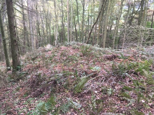
The monument includes a round barrow situated just below the top of the
east-facing scarp slope into the River Derwent valley, towards the northern
edge of the Tabular Hills.
The barrow has an earth and stone mound standing up to 0.8m high. It is round
in shape and measures 9m in diameter. In the centre of the mound there is a
hollow caused by part excavation in the past.
The barrow lies within a dense concentration of prehistoric burial monuments
in an area which also includes the remains of prehistoric settlement and land
division.
MAP EXTRACT
The site of the monument is shown on the attached map extract.
It includes a 2 metre boundary around the archaeological features,
considered to be essential for the monument's support and preservation.
Source: Historic England
Round barrows are funerary monuments dating from the Late Neolithic period to
the Late Bronze Age, with most examples belonging to the period 2400-1500 BC.
They were constructed as earthen mounds, sometimes ditched, which covered
single or multiple burials. They occur either in isolation or grouped as
cemeteries and often acted as a focus of burials in later periods. Often
superficially similar, although differing widely in size, they exhibit
regional variations in form and a diversity of burial practices. There are
over 10,000 surviving examples recorded nationally (many more have already
been destroyed), occurring across most of Britain, including the Wessex area
where it is often possible to classify them more closely, for example as bowl
or bell barrows. Often occupying prominent locations, they are a major
historic element in the modern landscape and their considerable variation in
form and longevity as a monument type provide important information on the
diversity of beliefs and social organisations amongst early prehistoric
communities. They are particularly representative of their period and a
substantial proportion of surviving examples are considered worthy of
protection.
The Tabular Hills in the Wykeham Forest area contain a dense concentration of
prehistoric monuments, dating from the Neolithic to the Iron Age, which
includes field systems, enclosures and land boundaries as well as both round
and square barrows. The spatial and chronological relationships between the
round and square barrows in this area, and between both types of barrow and
other prehistoric monuments, are of considerable importance for understanding
the development of later prehistoric society in eastern Yorkshire.
Despite limited disturbance, the barrow 330m south east of Coomb Slack Farm
survives well. Significant information about the original form of the barrow
and the burials placed within it will be preserved. Evidence for earlier land
use and the contemporary environment will also survive beneath the barrow
mound.
Source: Historic England
Books and journals
Lee, G E, Wykeham Archaeological Survey, (1991)
Other
Pacitto, A L, AM107, (1982)
Source: Historic England
Other nearby scheduled monuments