Approximate Location Map
Large Map »
This site is entirely user-supported. See how you can help.
Latitude: 51.9685 / 51°58'6"N
Longitude: -2.8928 / 2°53'33"W
OS Eastings: 338762.034667
OS Northings: 230376.205612
OS Grid: SO387303
Mapcode National: GBR FB.L532
Mapcode Global: VH78H.TS2B
Entry Name: Dore Abbey: a Cistercian monastery
Scheduled Date: 17 August 1976
Last Amended: 14 March 2000
Source: Historic England
Source ID: 1016433
English Heritage Legacy ID: 30011
County: Herefordshire,
Civil Parish: Abbey Dore
Traditional County: Herefordshire
Lieutenancy Area (Ceremonial County): Herefordshire
Church of England Parish: Abbeydore
Church of England Diocese: Hereford
The monument includes the earthwork and buried remains of the claustral
buildings and parts of the outer court and wider precinct of the Cistercian
abbey at Dore, as well as the standing remains of the nave of the abbey
church and the chapter house. The abbey is located in the steep sided valley,
just above the flood plain of the River Dore, and is sited close to the Roman
road which ran from Abbergavenny to Kenchester.
Dore Abbey was founded by Robert Fitz Harold of Ewyas about 1147. The main
complex of conventual buildings was erected between the mid-12th century and
1210 with the church aligned south east to north west and the cloister sited
to the north of the church rather than on the more usual southern side. This
was most probably due to the geographic restrictions of the site in a steep
sided valley which prevented the construction of the cloisters to the south.
The abbey was suppressed in 1536 and the buildings rapidly fell into ruins.
The church was restored in 1633 for John Viscount Scudemore. Between 1895-
1904, as part of further restorations, Roland Paul excavated and made measured
drawings of the remains of the monastic site. The excavations in the body of
the nave and in parts of the claustral range and the precinct clarified the
layout of the monastery and confirmed its overall compliance with the standard
Cistercian plan found in monasteries of the order throughout Europe.
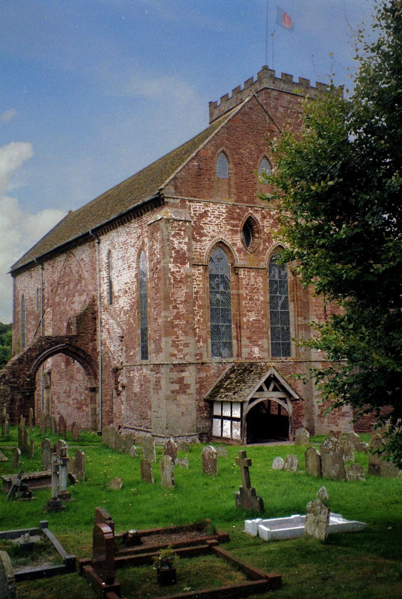
The chancel of the monastic church forms the extant parish church of the
village of Abbey Dore. The church, which is a Grade I Listed Building and
which remains in use, is excluded from the scheduling, although the ground
beneath it is included. Approximately 17 chest tombs, which are Listed Grade
II and located within the churchyard, are also excluded from the scheduling
although the ground beneath them is included. The whole of the churchyard is
included in the scheduling except for an area to the north west where more
recent burials occur.
The nave of the monastic church was largely demolished above ground level, and
the area is now occupied by the graveyard of the present parish church. Two
pillars of the nave immediately north west of the crossing, the arch of the
first bay of the southern arcade of the nave, now standing in the modern
graveyard, and the north wall, including the lay brothers day entrance into
the nave of the monastic church survive. The full extent of the nave and the
position of the Galilee porch are clearly evident as low earthwork banks and
platforms. There is a fall in ground level of 1m to 2m between the current
graveyard in the area of the monastic nave and the farm yard and buildings to
the north west of the church in the area of the conventual west range. In
addition, an area to the south east of the church which is thought to overlie
the site of the monastic cemetery is included in the scheduling.
Further traces of the conventual buildings survive as low earthwork banks and
platforms of the `frater range'(the range of buildings which contained the
warming rooms, dining rooms and kitchens and which was traditionally located
opposite to and running parallel with the church).
The east range of the cloister is indicated by extant remains of the sacristy
and walling and a springer for vaulting of the octagonal chapter house,
whilst the scar of the roof of the monastic dormitory and night stairs
entrance survive in the present north eastern gable of the north transept of
the church. There is another earthwork platform to the north east of the east
end of the church which is the traditional site of the monastic infirmary
cloister. Although the plan of this building has not been recorded in enough
detail to determine its use, it is certainly one of the major conventual
buildings beyond the claustral range.
In addition, there are traces of a boundary which takes the the form of a
substantial earthern bank to the east of the east end of the church where it
defined the inner court of the monastery. Other fragments of bank, to the east
and south of the church, indicate the course of the wider precinct boundary
incorporated in places among extant field boundaries.
Earthwork remains of the water management system of the monastery survive as a
ditch which follows the course of the main drain of the monastery. This
entered the inner court from the north west and flowed beneath the buildings
of the reredorter (lavatory), kitchens and infirmary and continued to the
north east acting as a leat for industrial purposes. Immediately to the east
of the inner court are the earthwork remains of a building, thought to be a
mill, which lie on the route of the leat. In the pasture to the south of the
leat are the shallow remains of at least three sub-rectangular ponds linked to
each other by channels and also linked to the main leat. These ponds are
thought to be the remains of monastic fish stews used for production of fish
for immediate domestic consumption.
Both the mill building and the fishponds lie within the area of the wider
precinct which is defined by the survival of a boundary bank to the south east
along the present field boundary. The precinct was defined along its southern
edge by the boundary bank which survives in places along the edge of the
modern road.
A number of features are excluded from the scheduling; these are the chancel
of the monastic church which forms the parish church, the modern churchyard
wall acting as the boundary to the churchyard, all chest tombs, the timber
porch, modern paths, fences and gates and the modern barns in the south
eastern part of the Tan House farmyard; the ground beneath all these features
is, however, included.
An area in the south eastern part of the monument is totally excluded from the
scheduling. This area includes the house, cottages, outbuildings and immediate
gardens of the Old Rectory. The house and cottages were built in the 19th
century and ground levels were reduced beyond the level where any
archaeological features are expected to survive. However, at the western and
southern extremities of the monument, surviving sections of the precinct
boundary wall lie within the gardens of Old Rectory house and cottages. These
remains are included in the scheduling.
MAP EXTRACT
The site of the monument is shown on the attached map extract.
Source: Historic England
From the time of St Augustine's mission to re-establish Christianity in AD 597
to the reign of Henry VIII, monasticism formed an important facet of both
religious and secular life in the British Isles. Settlements of religious
communities, including monasteries, were built to house communities of monks,
canons (priests), and sometimes lay-brothers, living a common life of
religious observance under some form of systematic discipline. It is estimated
from documentary evidence that over 700 monasteries were founded in England.
These ranged in size from major communities with several hundred members to
tiny establishments with a handful of brethren. They belonged to a wide
variety of different religious orders, each with its own philosophy. As a
result, they vary considerably in the detail of their appearance and layout,
although all possess the basic elements of church, domestic accommodation for
the community, and work buildings. Monasteries were inextricably woven into
the fabric of medieval society, acting not only as centres of worship,
learning and charity, but also, because of the vast landholdings of some
orders, as centres of immense wealth and political influence. They were
established in all parts of England, some in towns and others in the remotest
of areas. Many monasteries acted as the foci of wide networks including parish
churches, almshouses, hospitals, farming estates and tenant villages. Some 75
of these religious houses belonged to the Cistercian order founded by St
Bernard of Clairvaux in the 12th century. The Cistercians - or "white monks",
on account of their undyed habits - led a harsher life than earlier monastic
orders, believing in the virtue of a life of austerity, prayer and manual
labour. Seeking seclusion, they founded their houses in wild and remote areas
where they undertook major land improvement projects. Their communities were
often very large and included many lay brethren who acted as ploughmen,
dairymen, shepherds, carpenters and masons. The Cistercians' skills as farmers
eventually made the order one of the richest and most influential. They were
especially successful in the rural north of England where they concentrated on
sheep farming. The Cistercians made a major contribution to many facets of
medieval life and all of their monasteries which exhibit significant surviving
archaeological remains are worthy of protection.
Dore's position on a marginal site in the Welsh marches reflects the
ideology and aspirations recorded in statutes and histories of the mid-12th
century Cistercian order. Comparison between the written record and the
physical remains will contribute to a wider understanding of an order at its
zenith.
Although Cistercian monasteries conformed in general to a standard
architectural plan and the monks lived by a strict code of statutes governing
many aspects of their lives, the architecture of individual houses developed
over the centuries of their occupation. The part excavations of Roland
Paul have confirmed that whilst Dore conformed to the general Cistercian plan,
it also retained its own individual elements of style and design. The
octagonal chapter house and other architectural details suggest an influence
from the West Country school of builders, those involved in the construction
of the great religious buildings such as Wells Cathedral and Glastonbury
Abbey.
Dore Abbey is the only Cistercian house in England founded directly from the
great Cistercian House of Morimond, the fifth senior house of the order, whose
daughter houses lay largely in central and eastern Europe. The buildings at
Dore will provide insight into both the influence of local non-Cistercian
trends in architecture and of the great European monasteries within the
traditions of English Cistercian building and decoration.
The remarkable survival of the east end of the monastic church, now the parish
church, is the only occurrence of a Cistercian church still in ecclesiastical
use in England. The work of the 19th century restorers is remarkably well
understood, and the records of Roland Paul provide an opportunity to study
the development of a monastic building over 900 years. Traces of painted
plaster work discovered within the church have already provided one of the
more detailed insights into the decorative schemes within a Cistercian church,
similar survivals upon buried architectural fragments would further enhance
our knowledge.
The survival of the monastic cemetery will be expected to provide a rare
opportunity to examine the skeletal remains of a discrete medieval community
providing insight into living conditions, diet, health and funerary practices.
The low lying, damp position of the mill, leats and fishponds would suggest a
good level of survival of organic remains within the monastic precinct. This
environmental evidence will provide information about the natural and climatic
environment and also the economic development of the house.
Source: Historic England
Books and journals
Shoesmith, R, Richardson, R. et al, A Definitive History of Dore Abbey, (1997)
Paul, R, 'Transactions of the Bristol and Gloucester Archeaological Soc.' in Dore Abbey; The Church And Monastery, , Vol. XXVII, (1904), 117
Other
Result of collapsed sacristy, Liegh, J,., Feild Monument Warden Long Internal Report, (1997)
Series 007 March 1997, Stone, R, Abbey Dore Chapter House: A Report on Stone Recording, (1997)
Source: Historic England
Other nearby scheduled monuments