Approximate Location Map
Large Map »
This site is entirely user-supported. See how you can help.
Latitude: 52.4473 / 52°26'50"N
Longitude: -2.243 / 2°14'34"W
OS Eastings: 383578.292128
OS Northings: 283286.916092
OS Grid: SO835832
Mapcode National: GBR 1C0.HQV
Mapcode Global: VH91G.2RK8
Entry Name: Kinver camp, a univallate hillfort
Scheduled Date: 19 January 1970
Last Amended: 1 August 1996
Source: Historic England
Source ID: 1015432
English Heritage Legacy ID: 21634
County: Staffordshire
Civil Parish: Kinver
Built-Up Area: Kinver
Traditional County: Staffordshire
Lieutenancy Area (Ceremonial County): Staffordshire
Church of England Parish: Kinver St Peter
Church of England Diocese: Lichfield
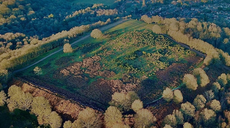
The monument is situated at the northern western corner and highest point of
the Kinver escarpment, on the south western outskirts of the village of
Kinver. It includes the earthwork and buried remains of a univallate Iron Age
hillfort.
Kinver camp is sub-rectangular in plan with external dimensions of
approximately 210m north west-south east and up to 300m north east-south west.
The defensive earthworks include a single bank and an external ditch along two
of its four sides, whilst the naturally steep gradient of the escarpment is
thought to have made the construction of a ditch along the hillfort's north
western and north eastern sides unnecessary. The bank and ditch, therefore,
define the south western and south eastern sides of the hillfort and terminate
at, or close to, the edge of the escarpment at both ends. The ditch is
approximately 24m wide and partly silted. Its north eastern and north western
terminals have later been modified by small-scale quarrying and there is no
surface evidence for the ditch at these points. The internal bank runs
parallel to the ditch and still stands to a height of 8m-9m above the base of
the ditch and 2m-3m above the hillfort interior. Towards the north western end
of the south western rampart is a small brick-built structure which has been
terraced into the outside of the bank. It is a former World War II shelter for
the Home Guard and is included in the scheduling in order to secure the
evidence for more recent defensive uses of the site. Parallel with, and some
3m from the internal face of the bank, are the remains of a low, linear
earthwork up to 0.8m high, whilst approximately 5m beyond the external ditch,
is a further low bank which also runs parallel with the defensive earthworks.
These features, although giving the impression of an interior berm and an
external counterscarp bank, are believed to be headlands resulting from 19th
century ploughing around and within the hillfort following its incorporation
into a rectilinear field system.
Surface evidence for defences along the north western and north eastern sides
of the hillfort is much less clearly visible although there is a low bank
running along the former and a slight earthwork at the north eastern corner.
The low bank is 0.7m high and can be traced intermittently for approximately
170m parallel to the edge of the scarp. It is believed to represent part of
the defences along the north western side of the hillfort and is now
surmounted by a discontinuous thorn hedge which has survived from its later
use as a field boundary (which is marked on early Ordnance Survey maps). The
slight earthwork at the north eastern corner of the site may represent an
original defensive feature and is included in the scheduling.
The original access into the interior is thought to have been at the north
eastern end of the south eastern defences. Although the quarrying and later
access arrangements in this area have resulted in a section of the ditch
becoming infilled, there is no evidence of the ditch re-emerging within the
natural scarp edge immediately to the north east, indicating that there is an
original terminus to the ditch beneath the modern path and suggesting an
entrance which has been partly lost through erosion and partly buried.
The hillfort's earthworks enclose an area of approximately 3.75ha, the ground
surface of which slopes considerably towards the south east and south. No
internal earthworks associated with the occupation of the hillfort are visible
within the interior, but the build-up of the ground surface, particularly
alongside the south eastern rampart, will preserve stratified occupation
deposits.
The toposcope in the northern part of the interior, the steps built into the
north western and south western sides of the monument and the concrete
retaining wall at the northern corner of the hillfort are excluded from the
scheduling but the ground beneath these features is included.
MAP EXTRACT
The site of the monument is shown on the attached map extract.
Source: Historic England
Large univallate hillforts are defined as fortified enclosures of varying
shape, ranging in size between 1ha and 10ha, located on hilltops and
surrounded by a single boundary comprising earthworks of massive proportions.
They date to the Iron Age period, most having been constructed and used
between the fourth century BC and the first century AD, although evidence for
earlier use is present at most sites. The size of the earthworks reflects the
ability of certain social groups to mobilise the labour necessary for works on
such a monumental scale, and their function may have had as much to do with
display as defence. Large univallate hillforts are also seen as centres of
redistribution, both for subsistence products and items produced by craftsmen.
The ramparts are of massive proportions except in locations where steepness of
slope precludes easy access. They can vary between 6m and 20m wide and may
survive to a height of 6m. The ditches can measure between 6m and 13m wide and
between 3m and 5m deep. Access to the interior is generally provided by one or
two entrances which often take the form of long passages formed by inturned
ramparts and originally closed by a gate located towards the inner end of the
passageway. The entrance may be flanked by guardrooms and/or accompanied by
outworks. Internal features included timber or stone round houses; large
storage pits and hearths; scattered postholes, stakeholes and gullies; and
square or rectangular buildings supported by four to six posts, often
represented by postholes, and interpreted as raised granaries. Large
univallate hillforts are rare with between 50 and 100 examples recorded
nationally. Most are located within southern England where they occur on the
chalklands of Wessex, Sussex and Kent. The western edge of the distribution is
marked by scattered examples in north Somerset and east Devon, while further
examples occur in central and western England and outliers further north.
Within this distribution considerable regional variation is apparent, both in
their size, rampart structure and the presence or absence of individual
components. In view of the rarity of large univallate hillforts and their
importance in understanding the organisation and regional structure of Iron
Age society, all examples with surviving archaeological remains are believed
to be of national importance.
Kinver camp survives well and is a good example of this type of hillfort.
Within the interior of the site, buried structural and artefactual evidence
associated with the development and occupation of the hillfort will survive in
good condition. Immediately behind the south eastern and south western
ramparts in particular, there is likely to be a well stratified sequence of
deposits which, together with the environmental evidence retained within the
defensive ditch, will provide information on the economy of the site's
inhabitants and the landscape in which they lived.
Kinver Camp is accessible to the public and serves as a valuable educational
and recreational resource.
Source: Historic England
Books and journals
RCHME, , Kinver Camp, (1993), 3
RCHME, , Kinver Camp, (1993), 2
Source: Historic England
Other nearby scheduled monuments