Approximate Location Map
Large Map »
This site is entirely user-supported. See how you can help.
Latitude: 50.8324 / 50°49'56"N
Longitude: -2.5242 / 2°31'27"W
OS Eastings: 363180.4372
OS Northings: 103779.544449
OS Grid: ST631037
Mapcode National: GBR MT.WY0L
Mapcode Global: FRA 56LW.Y5M
Entry Name: Cross and Hand wayside cross 670m south of the Friary of St Francis
Scheduled Date: 23 October 1954
Last Amended: 18 November 1996
Source: Historic England
Source ID: 1015041
English Heritage Legacy ID: 27441
County: Dorset
Civil Parish: Batcombe
Traditional County: Dorset
Lieutenancy Area (Ceremonial County): Dorset
Church of England Parish: Batcombe St Mary
Church of England Diocese: Salisbury
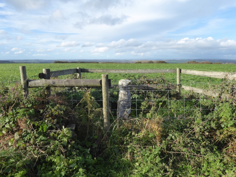
The monument includes a wayside cross 670m south of the Friary of St Francis.
The cross includes a monolithic oval shaft, 0.82m in diameter and 1m high with
a crudely carved collar and larger rounded head. The hand, said to have been
carved on one face, is no longer traceable and an Ordnance Survey benchmark
has been carved near the base on the southern side of the pillar.
It is possible that this cross belongs to the group of pre-Conquest shafts of
which the pillar of Eliseg, which is said to be 6th century in date, is the
best known.
The cross is decribed by Hardy in Tess of the D'Urbevilles as a `strange rude
monolith'. The cross is Listed Grade II.
MAP EXTRACT
The site of the monument is shown on the attached map extract.
Source: Historic England
Wayside crosses are one of several types of Christian cross erected during the
medieval period, mostly from the 9th to 15th centuries AD. In addition to
serving the function of reiterating and reinforcing the Christian faith
amongst those who passed the cross and of reassuring the traveller, wayside
crosses often fulfilled a role as waymarkers, especially in difficult and
otherwise unmarked terrain. The crosses might be on regularly used routes
linking ordinary settlements or on routes having a more specifically religious
function, including those providing access to religious sites for parishioners
and funeral processions, or marking long-distance routes frequented on
pilgrimages.
Over 350 wayside crosses are known nationally, concentrated in south west
England throughout Cornwall and on Dartmoor where they form the commonest type
of stone cross. A small group also occurs on the North York Moors. Relatively
few examples have been recorded elsewhere and these are generally confined to
remote moorland locations.
Outside Cornwall almost all wayside crosses take the form of a `Latin' cross,
in which the cross-head itself is shaped within the projecting arms of an
unenclosed cross. In Cornwall wayside crosses vary considerably in form and
decoration. The commonest type includes a round, or `wheel', head on the faces
of which various forms of cross or related designs were carved in relief or
incised, the spaces between the cross arms possibly pierced. The design was
sometimes supplemented with a relief figure of Christ and the shaft might bear
decorative panels and motifs. Less common forms in Cornwall include the
`Latin' cross and, much rarer, the simple slab with a low relief cross on both
faces. Rare examples of wheel-head and slab-form crosses also occur within the
North York Moors group. Most wayside crosses have either a simple socketed
base or show no evidence for a separate base at all.
Wayside crosses contribute significantly to our understanding of medieval
religious customs and sculptural traditions and to our knowledge of medieval
routeways and settlement patterns. All wayside crosses which survive as earth-
fast monuments, except those which are extremely damaged and removed from
their original locations, are considered worthy of protection.
Despite the fact that the head has been removed, the Cross and Hand wayside
cross 670m south of the Friary of St Francis is well preserved and, surviving
in its original position, remains an important example of its class.
Source: Historic England
Other
Historical Monuments in the county of Dorset, (1976)
Source: Historic England
Other nearby scheduled monuments