Approximate Location Map
Large Map »
This site is entirely user-supported. See how you can help.
Latitude: 52.2936 / 52°17'37"N
Longitude: -0.3978 / 0°23'51"W
OS Eastings: 509368.045384
OS Northings: 267374.276406
OS Grid: TL093673
Mapcode National: GBR H1N.28P
Mapcode Global: VHFPJ.2M22
Entry Name: Motte castle in Kimbolton Park, known as Castle Hill
Scheduled Date: 1 October 1954
Last Amended: 30 August 1996
Source: Historic England
Source ID: 1015013
English Heritage Legacy ID: 27171
County: Cambridgeshire
Civil Parish: Kimbolton
Traditional County: Huntingdonshire
Lieutenancy Area (Ceremonial County): Cambridgeshire
Church of England Parish: Kimbolton St Andrew
Church of England Diocese: Ely
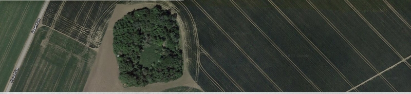
Castle Hill motte stands on a slight spur about 270m north of Park Lodge,
overlooking the flood plain of the River Kym and village of Kimbolton to the
north.
The castle was constructed by digging a broad circular ditch around the tip of
the spur, encircling a small area which was raised using the upcast to form a
mound or motte. The motte (also circular in plan) measures about 30m in
diameter and now stands approximately level with the outer edge of the ditch
to the south, and 1.8m above the rim of the ditch to the north where the
ground falls away at the end of the spur. The surface of the motte, which
would originally have supported a timber tower, has a slightly domed profile.
The surrounding ditch varies between 1m and 2.5m in depth, deepest to the
south to compensate for the rising ground. Although it was recorded as water
filled in the early part of this century, the ditch is now dry and contains
deep deposits of humic silt. The ditch also varies in width from about 15m
around the southern part of the circuit narrowing to about 10m around the
northern half, which is accompanied by an outer counterscarp bank averaging 5m
across and 0.6m high. In the absence of a causeway across the ditch access to
the motte is thought to have been via a bridge.
The castle is believed to have originated in the mid 12th century during the
period of civil war known as the Anarchy. Kimbolton Park, in which the
monument stands, was enclosed as a deer park by the 16th century, and it has
been suggested that the motte may have been reused as a hunting lodge for a
time. The monument is shown on Thomas Stirrup's estate map of 1673 under the
name Castle Hill.
All fences and fenceposts are excluded from the scheduling although the ground
beneath is included.
MAP EXTRACT
The site of the monument is shown on the attached map extract.
It includes a 2 metre boundary around the archaeological features,
considered to be essential for the monument's support and preservation.
Source: Historic England
Motte castles are medieval fortifications introduced into Britain by the
Normans. They comprised a large conical mound of earth or rubble, the motte,
surmounted by a palisade and a stone or timber tower. In a majority of
examples an embanked enclosure containing additional buildings, the bailey,
adjoined the motte. Motte castles and motte-and-bai1ey castles acted as
garrison forts during offensive military operations, as strongholds, and, in
many cases, as aristocratic residences and as centres of local or royal
administration. Built in towns, villages and open countryside, motte castles
generally occupied strategic positions dominating their immediate locality
and, as a result, are the most visually impressive monuments of the early
post-Conquest period surviving in the modern landscape. Over 600 motte castles
and motte-and-bailey castles are recorded nationally, with examples known from
most regions. Some 100-150 examples do not have baileys and are classified as
motte castles. As one of a restricted range of recognised early post-Conquest
monuments, they are particularly important for the study of Norman Britain and
the development of the feudal system. Although many were occupied for only a
short period of time, motte castles continued to be built and occupied from
the 11th to the 13th centuries, after which they were superseded by other
types of castle.
Castle Hill is a well preserved example of a medieval motte castle. The mound
will retain buried evidence for the structure which stood on the summit, and
the silts within the surrounding ditch will contain both artefacts and
environmental evidence relating to the limited period of occupation. The old
ground surface buried beneath the mound is also of considerable significance
as it may retain evidence of former land use which will have been degraded
elsewhere by more recent cultivation. The strategic position of the castle
provides an illustration of its defensive role during the Anarchy.
Source: Historic England
Books and journals
The Victoria History of the County of Huntingdonshire, (1936), 77
Taylor, A, Castles of Cambridgeshire, (1990), 16
Other
Kimbolton Park, 0255,
Site class designation, 0689,
Title: HRO PM 314
Source Date: 1673
Author:
Publisher:
Surveyor:
Estate map (Huntindon Record Office)
Source: Historic England
Other nearby scheduled monuments