Approximate Location Map
Large Map »
This site is entirely user-supported. See how you can help.
Latitude: 51.4433 / 51°26'35"N
Longitude: 0.377 / 0°22'37"E
OS Eastings: 565288.915688
OS Northings: 174267.872486
OS Grid: TQ652742
Mapcode National: GBR NML.D4S
Mapcode Global: VHJLC.HZ5G
Entry Name: New Tavern Fort, Gravesend, including Milton Chantry
Scheduled Date: 15 June 1995
Source: Historic England
Source ID: 1013658
English Heritage Legacy ID: 24358
County: Kent
Electoral Ward/Division: Riverside
Built-Up Area: Gravesend
Traditional County: Kent
Lieutenancy Area (Ceremonial County): Kent
Church of England Parish: Milton St Peter and St Paul
Church of England Diocese: Rochester
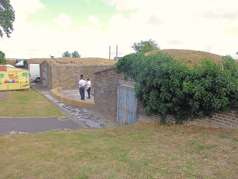
The monument includes the upstanding and below ground remains of New Tavern Fort which includes within its grounds the earlier chapel or chantry associated with the Leper Hospital of St Mary the Virgin at Milton by Gravesend. The monument lies near Gravesend Pier and close to the River Thames. Both the fort and the chantry are Listed Grade II*. The chantry is situated at the north west side of the fort.
New Tavern Fort was built as a result of the 1778 survey of the defensive requirements of the Thames. Fear of a French invasion led to the fort being built to provide cross fire with Tilbury on the other side of the river. Originally New Tavern Fort consisted of a battery on two faces forming an angle towards the river with a strip of rampart joining it to a smaller, straight battery, defended to the front by a flat-bottomed ditch containing a wooden palisade c.3m high. The fort was constructed of unrevetted earth and was designed for an armament of heavy, smooth-bore cannon firing through embrasures. The rear of the fort was originally open and unprotected but before the end of the century a brick wall, with loopholes for musketry, was added.
Although the initial construction was between 1780 and c.1783, the armament of the fort was updated and increased at intervals throughout the 19th century. In the 1840s the fort was modernised to take a heavier armament, which involved the reconstruction of the older gun emplacements, but this did not alter the basic plan of the fort. A magazine designed to hold 250 barrels of powder was built close to the chantry building, and another smaller magazine, for 50 barrels, was established nearby. Other new buildings constructed at this time included a wash-house, coal store and a guardroom. Once again, in the 1860s and 1870s, the development of large guns forced improvements in the design and armament of coastal defences and so between 1868 and 1872 new brick emplacements for 10 heavy guns were constructed, with magazines below. Again, however, the plan of the fort was not altered.
By the end of the 19th century muzzle-loaded guns had become obsolete, and the perceived danger from breech-loading weapons mounted on enemy warships meant that emphasis was placed on strengthening defences downstream from Gravesend, and thus New Tavern Fort lost some of its strategic importance. In 1905 concrete emplacements for two six-inch breech-loading guns were built, joined together by a walkway with a separate magazine underneath. Although the fort was garrisoned during World War I, its strategic importance continued to decline. In 1930 it was purchased by the Gravesend Corporation who laid it out as a pleasure garden for the public. During the Second World War the magazine built for the breech-loading guns was used for a time as an air raid shelter. Since then the site has again been cultivated as a public garden. In the north west corner of the fort is the earlier chantry building and associated priests' house. The chantry is a long, rectangular, stone-walled building with a central partition. It now contains two timber floors, which were added once the building passed into domestic use in the 16th century, along with the 17th century staircase. The stone building has been dated to c.1300, and still retains its original 14th century arch-braced roof. A timber-framed building runs out at right angles from the south wall of the chantry. This was the priests' house and contains part of an aisled hall dating to c.1321, along with a queen post roof. Both the chantry building and the priests' house were encased in red and yellow brick in the 18th and 19th centuries when they were part of the barracks of the fort.
The exact origin of Milton Chantry is unknown, although lands in Essex granted to the hospital at Gravesend are mentioned in the Pipe Rolls as far back as anno 2 Henry II (1155/6). The chantry then appears to have been refounded by Aylmer de Valence, Earl of Pembroke, in 1321 when he made a grant to Roger de Stowe, master of the chantry, and all the brethren of the site and lands of the chapel and all the lands pertaining to it in the hundreds of Barnstaple and Rochford in Essex. He also directed that there should be a master priest, an assistant and two chaplains, all of whom should be appointed by the Bishop of Rochester, and that they should pray for the souls of de Valence and his family and also for the Montechasie family who had been the former lords of the manor. In 1524 an Inquisition was taken which found that the master and brethren had died without a new master being elected, and thus the chantry was automatically dissolved and passed into Crown hands. It was then granted to Sir Henry Wyatt to be refounded as a chantry of two chaplains. Sir Henry died in 1537, and by 1540 the clergy had been dismissed and the building had come into domestic use. In the late 17th century it was used as a tavern, and in 1780 the building was incorporated into the property of the New Tavern Fort as accommodation. The chantry was sold to Gravesend Council by the War Department in 1930, and during the Second World War the basement was prepared as a gas decontamination centre in anticipation of gas warfare. The building was passed into State care in 1972.
All upstanding and below ground remains of the chantry and fort (including the late-C19 angle-iron ‘Dacoit’ fencing which marks the eastern boundary of the monument) are included in the scheduling. All modern features within the chantry, such as the reception bar, water heater, light fittings and the English Heritage information sign are excluded. Within the Fort Gardens all bill-boards, notice boards, information display boards, rubbish bins, dog litter bins, benches, wooden and metal railing fences, modern brick walls, brick and stone-lined flower beds, stone paving and the surfaces of all paths are excluded. Also excluded are all canon, guns and shells on display, the sentry box, toilet blocks, modern reconstructions of gun and traversing platforms, the bandstand, all concrete steps and the metal staircases which have been added to the northern magazine block, the modern structure to the north of the fort ditch, the wooden bridges in the defensive ditch, stone edging along the path half- way down the earthen revetment, all modern fittings associated with the magazines (doors, windows, notices), the modern stone `amphitheatre' built into the ditch of the fort, the wrought iron gates at the southern entrance and all below ground service trenches and their above ground access points; the ground beneath all these features is, however, included in the scheduling.
MAP EXTRACT
The site of the monument is shown on the attached map extract.
Source: Historic England
New Tavern Fort is an unusually complete example of 18th century fortifications which underwent development in the 19th and 20th centuries. The fort displays a complete sequence of mounted guns representing each stage in its development, and contains a number of unusual features which have been preserved in situ. The site is known for its connection with General Charles Gordon who lived here from 1865-71 and was later killed at Khartoum. The foundations of his house still survive within the fort.
The fort itself, along with Tilbury on the opposite bank of the Thames, illustrates well the strategic importance of the Thames Estuary and the methods employed to defend it over a period of 170 years. The fort is particularly well preserved, having been maintained over a number of years by the New Tavern Fort Project.
In the north west corner of the fort is Milton Chantry, a 14th century building representing the chapel of a medieval hospital. A medieval hospital is a group of buildings housing a religious or secular institution which provided spiritual and medical care. The idea for such institutions originated in the Anglo-Saxon period although the first definite foundations were created by Anglo-Norman bishops and queens in the 11th century. Documentary sources indicate that by the mid-16th century there were around 800 hospitals. A further 300 are also thought to have existed but had fallen out of use by this date. Half of the hospitals were suppressed by 1539 as part of the Dissolution of the Monasteries. Some smaller institutions survived until 1547 when they were dissolved by Edward VI. Many of these smaller hospitals survived as almshouses, some up to the present day.
Despite the large number of hospitals known from documentary sources to have existed, generally only the larger religious ones have been exactly located. Few hospitals retain upstanding remains and very few have been examined by excavation. In view of these factors, all positively identified hospitals retaining significant medieval remains will be considered nationally important.
Milton Chantry has a well documented history from the early 14th century onwards and has undergone a variety of uses. Despite this, the building has survived intact and contains numerous well preserved architectural features dating from the 14th to the 19th centuries. Archaeological remains will also survive in, around and underneath the chantry building relating to the chantry itself and the hospital of which it was a part. Although Milton Chantry follows one of the more common plans of chantry foundations, very few of these have survived intact or are as well preserved.
Source: Historic England
Other nearby scheduled monuments