Approximate Location Map
Large Map »
This site is entirely user-supported. See how you can help.
Latitude: 52.9389 / 52°56'20"N
Longitude: 1.0935 / 1°5'36"E
OS Eastings: 607970.85574
OS Northings: 342429.278173
OS Grid: TG079424
Mapcode National: GBR T8Z.M9P
Mapcode Global: WHLQV.RDW8
Entry Name: Gallow Hill bowl barrow and adjacent group of eight bowl barrows: part of a barrow cemetery on and around Salthouse Heath
Scheduled Date: 26 June 1924
Last Amended: 30 October 1995
Source: Historic England
Source ID: 1013564
English Heritage Legacy ID: 21362
County: Norfolk
Civil Parish: Kelling
Traditional County: Norfolk
Lieutenancy Area (Ceremonial County): Norfolk
Church of England Parish: Kelling St Mary
Church of England Diocese: Norwich
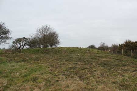
The monument, which is divided into two areas separated by Wood Lane, includes
the large bowl barrow known as Gallow Hill, and eight smaller bowl barrows
adjacent to it on the south and south east sides. These barrows form a
distinct cluster on the eastern side of a dispersed round barrow cemetery
which extends over an area of c.1.3 sq km. Gallow Hill, in the area to the
north of the road, is visible as an earthen mound encircled by a ditch and the
remains of a bank around the outer edge of the ditch. The mound stands to a
height of c.2m and covers a circular area c.27m in diameter. A slight
depression c.6m wide in the surface of the mound, extending from the southern
edge towards the centre, is perhaps the result of an antiquarian excavation.
The surrounding ditch, from which earth was dug during the construction of the
barrow, has become partly infilled, but is marked by a hollow c.3m wide in the
ground surface, except on the north side of the mound, where it has been
completely infilled by ploughing but will survive as a buried feature. The
bank remains upstanding on the west and east sides of the barrow to a height
of c.0.4m and measures c.4m wide at the base. The barrow therefore has a
maximum overall diameter of 41m.
The eight associated barrows are situated in the second area, immediately to
the south of Wood Lane, and are visible as smaller earthen mounds lying on a
WSW-ENE alignment. Six of them are in a direct line, with two more slightly to
the north west of this and south west of Gallow Hill. At the eastern end of
the main alignment are three contiguous mounds. The easternmost of these lies
c.45m ESE of Gallow Hill and measures c.1m in height and c.17m in diameter.
The second, to the west of the first, measures c.0.5m in height and c.12m in
diameter, and the third and most prominent of the three, which lies c.28m
south east of Gallow Hill, measures c.1.2m in height and c.17m in diameter.
Beyond this, at a distance of c.5m, is a fourth mound c.0.6m high and c.16m in
diameter. Immediately to the north and south of these mounds are slight
hollows c.3m wide in the ground surface, which are considered to mark
surrounding ditches, now largely infilled but surviving as buried features.
The fifth barrow mound lies c.12m to the west of the fourth and c.25m south of
Gallow Hill and is contiguous with the sixth, at the western end of the line.
Both measure c.12m in diameter and c.1m in height. The seventh, lying c.6m
north west of these and the eighth, at a distance of c.16m WNW from them, are
of similar height and c.14m in diameter. It is likely that these mounds, also,
are surrounded by buried ditches. A narrow farm track crosses the area of the
buried ditch on the east side of the easternmost barrow, the surface of this
track is excluded from the scheduling although the ground beneath it is
included.
MAP EXTRACT
The site of the monument is shown on the attached map extract.
It includes a 2 metre boundary around the archaeological features,
considered to be essential for the monument's support and preservation.
Source: Historic England
Round barrow cemeteries date to the Bronze Age (c.2000-700 BC). They comprise
closely-spaced groups of up to 30 round barrows - rubble or earthen mounds
covering single or multiple burials. Most cemeteries developed over a
considerable period of time, often many centuries, and in some cases acted as
a focus for burials as late as the early medieval period. They exhibit
considerable diversity of burial rite, plan and form, frequently including
several different types of round barrow, occasionally associated with earlier
long barrows. Where large scale investigation has been undertaken around them,
contemporary or later "flat" burials between the barrow mounds have often been
revealed. Round barrow cemeteries occur across most of lowland Britain, with a
marked concentration in Wessex. In some cases, they are clustered around other
important contemporary monuments such as henges. Often occupying prominent
locations, they are a major historic element in the modern landscape, whilst
their diversity and their longevity as a monument type provide important
information on the variety of beliefs and social organisation amongst early
prehistoric communities. They are particularly representative of their period
and a substantial proportion of surviving or partly-surviving examples are
considered worthy of protection.
Gallow Hill and the eight smaller barrows adjacent to it survive well, both
individually and as a group, and although there are indications that Gallow
Hill has undergone some disturbance in the past, the area of this disturbance
is small in relation to the barrow as a whole. Archaeological information
concerning the construction and use of the barrows and their stratigraphic and
chronological relationship to one another, as well as evidence for the local
environment in the prehistoric period, will be retained in the upstanding
earthworks, in soils buried beneath the barrow mounds and the bank around
Gallow Hill, and in the fill of the surrounding ditches. This closely
associated group is an important component of the largest barrow cemetery in
Norfolk, and in that context has a wider significance for the study of the
character and development of the prehistoric population of the area.
Source: Historic England
Other nearby scheduled monuments