Approximate Location Map
Large Map »
This site is entirely user-supported. See how you can help.
Latitude: 51.1963 / 51°11'46"N
Longitude: 0.2735 / 0°16'24"E
OS Eastings: 558949.293218
OS Northings: 146577.895693
OS Grid: TQ589465
Mapcode National: GBR MP0.XN7
Mapcode Global: VHHQ6.P6G7
Entry Name: Tonbridge Castle
Scheduled Date: 13 January 1915
Last Amended: 9 October 1991
Source: Historic England
Source ID: 1013359
English Heritage Legacy ID: 12868
County: Kent
Electoral Ward/Division: Castle
Built-Up Area: Tonbridge
Traditional County: Kent
Lieutenancy Area (Ceremonial County): Kent
Church of England Parish: Tonbridge St Peter and St Paul
Church of England Diocese: Rochester
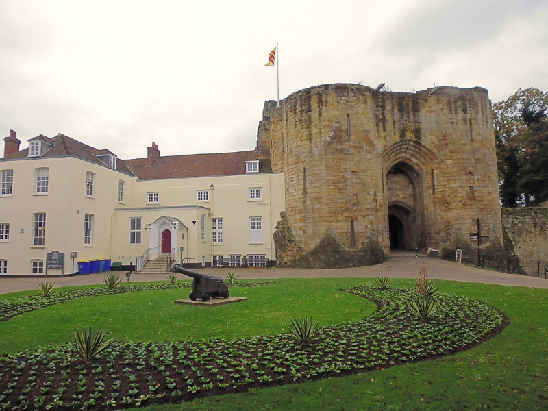
The monument includes a motte and bailey castle dating from the years soon
after the Norman Conquest, as well as the later remains of the curtain wall
and the 13th century gatehouse.
The principle feature of the earliest castle on the site is the earthen motte,
circular in plan and 20m high. At its summit the motte measures 24m by 20m.
Around the flattened top a wall was built to form a shell keep. The
foundations of a number of buildings which backed onto the shell keep wall and
a well were located during excavations in 1912 which resulted in the 7m wide
depression visible today. The shell keep wall has been partially rebuilt in
recent times to a height of ca.1m. The motte was originally encircled by a
moat of some 14m width but this was infilled on the eastern side in the 12th
century to ease access to and from the motte.
Below the motte and to the east was a bailey, the line of which was
consolidated by a tall stone curtain wall added in the 12th century which was
in turn strengthened by a now-infilled outer moat on the east and north-east
sides and to the south by the river. Inside the bailey the foundations of a
number of buildings including a chapel are considered likely to survive.
In the later 13th century, the original gatehouse was replaced with another
with drum towers flanking a strongly-defended gateway. A wall-walk connected
the new gatehouse with the keep. Many architectural details survive in the
gatehouse, including sculpted windows and arrowloops.
The Georgian buildings east of the gatehouse are excluded from the scheduling
along with all service trenches, modern paths, steps and display boards, but
the ground beneath is included.
MAP EXTRACT
The site of the monument is shown on the attached map extract.
It includes a 2 metre boundary around the archaeological features,
considered to be essential for the monument's support and preservation.
Source: Historic England
Motte castles are medieval fortifications introduced into Britain by the
Normans. They comprised a large conical mound of earth or rubble, the motte,
surmounted by a palisade and a stone or timber tower. In a majority of
examples an embanked enclosure containing additional buildings, the bailey,
adjoined the motte. Motte castles and motte-and-bai1ey castles acted as
garrison forts during offensive military operations, as strongholds, and, in
many cases, as aristocratic residences and as centres of local or royal
administration. Built in towns, villages and open countryside, motte castles
generally occupied strategic positions dominating their immediate locality
and, as a result, are the most visually impressive monuments of the early
post-Conquest period surviving in the modern landscape. Over 600 motte castles
and motte-and-bailey castles are recorded nationally, with examples known from
most regions. Some 100-150 examples do not have baileys and are classified as
motte castles. As one of a restricted range of recognised early post-Conquest
monuments, they are particularly important for the study of Norman Britain and
the development of the feudal system. Although many were occupied for only a
short period of time, motte castles continued to be built and occupied from
the 11th to the 13th centuries, after which they were superseded by other
types of castle.
The castle at Tonbridge survives well despite the partial excavation of the
motte top in the early 20th century and the adaptation of parts of the castle
for Georgian residences. The diversity of features at the castle is high,
including for example the architectural details of the gatehouse and the
garderobe chutes in the curtain wall in addition to the shell keep. In
addition the castle is well documented historically as a place frequented by
royalty, which together with good public access and informative displays makes
the castle of high amenity value.
Source: Historic England
Books and journals
Verhoeven, J, Tonbridge Castle - a short history and guide
Source: Historic England
Other nearby scheduled monuments