Approximate Location Map
Large Map »
This site is entirely user-supported. See how you can help.
Latitude: 52.4787 / 52°28'43"N
Longitude: -1.5891 / 1°35'20"W
OS Eastings: 428005.743523
OS Northings: 286827.573245
OS Grid: SP280868
Mapcode National: GBR 5JT.M26
Mapcode Global: VHBWJ.DYSQ
Entry Name: Ringwork castle 80m south west of Castle Farm
Scheduled Date: 16 May 1951
Last Amended: 28 June 1995
Source: Historic England
Source ID: 1013152
English Heritage Legacy ID: 21573
County: Warwickshire
Civil Parish: Fillongley
Built-Up Area: Fillongley
Traditional County: Warwickshire
Lieutenancy Area (Ceremonial County): Warwickshire
Church of England Parish: Fillongley St Mary and All Saints
Church of England Diocese: Coventry
The monument is situated approximately 80m south west of Castle Farm on the
southern outskirts of the village of Fillongley. It includes the masonry and
earthwork remains of Castle Yard, a ringwork castle and its associated bailey.
The site occupies an area of approximately 2ha and has been constructed on an
area of land which is defined by two stream channels. The stream to the north
of the ringwork flows west-east and forms the northern boundary to the site,
whilst the second stream, situated in the eastern part of the site, flows from
east to north. A third stream channel runs through the central part of the
site and flows northwards into the stream defining the site's northern edge.
The streams are thought to have been diverted at the time of the castle's
construction in order to form its southern outer defences. They also provided
the water supply for the inner defensive ditches. The ringwork itself, is
situated in the western part of the site and is surrounded by a 12m wide ditch
which, with the exception of its waterlogged northern section, is mostly dry.
The water supply for the ditch originally entered from the west and the south.
An external rampart is visible beyond the western, northern and southern sides
of the ditch. The ringwork has a roughly circular plan and has been
artificially raised above the surrounding ground surface. Traces of an inner
bank are visible along the north eastern and western sides of the ringwork
enclosure; this bank is thought to have been present originally on all sides.
Access into the ringwork is thought to have been by means of a causeway across
the eastern section of its enclosing ditch. The ringwork enclosure itself has
an uneven surface, indicating the survival of buried features beneath the
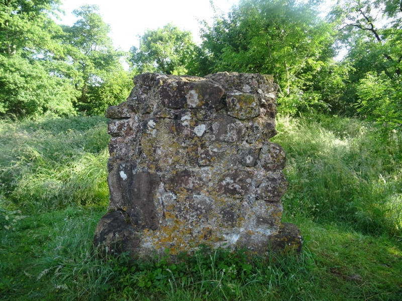
ground surface. In the north eastern part of the ringwork a large block of
in situ masonry is visible standing to a height of c.1.9m. It is built of
local sandstone and represents a rectangular building. The remains of a
circular staircase, situated adjacent to the block of standing masonry, have
been uncovered in the past though they now lie buried beneath the ground
surface. Fragments of masonry are also visible in the north eastern parts of
the enclosure.
To the north east, east and south east of the ringwork is a polygonal-shaped
bailey. It is bounded along its north western side by the northern stream
channel, and to the east and south, by a 6m wide ditch; the ringwork ditch
defines the bailey's western side. The north eastern section of the bailey
ditch has been infilled and is no longer visible on the ground surface. It is
thought to have connected with the northern stream channel and will survive as
a buried feature. A stream channel now flows north/south through the central
part of the bailey. A dry, 10m wide channel, aligned south west-north east, is
visible in the northern part of the bailey. This feature is thought to be
original and divides the bailey into two courts.
Castle Yard was occupied by the Hastings family from the early 12th century
and the site became their chief residence in Warwickshire. The last of the
Hastings line died in 1389 and the site became part of the Bergavenny baronry
which was held by the Beauchamps and the Nevilles. Castle Yard is thought to
have been abandoned during the late 14th or early 15th century.
All fence posts at the site are excluded from the scheduling, but the ground
beneath them is included.
MAP EXTRACT
The site of the monument is shown on the attached map extract.
Source: Historic England
Ringworks are medieval fortifications built and occupied from the late
Anglo-Saxon period to the later 12th century. They comprised a small defended
area containing buildings which was surrounded or partly surrounded by a
substantial ditch and a bank surmounted by a timber palisade or, rarely, a
stone wall. Occasionally a more lightly defended embanked enclosure, the
bailey, adjoined the ringwork. Ringworks acted as strongholds for military
operations and in some cases as defended aristocratic or manorial settlements.
They are rare nationally with only 200 recorded examples and less than 60
with baileys. As such, and as one of a limited number and very restricted
range of Anglo-Saxon and Norman fortifications, ringworks are of particular
significance to our understanding of the period.
Castle Yard survives well and is one of only two known examples of this class
of monument in Warwickshire. The foundations of medieval structures will
survive as buried features within both the ringwork and the bailey, while the
accumulated fill of the ringwork and bailey ditches will retain information
valuable for an understanding of the environment and economy of the site's
inhabitants. Additionally, the buried land surface beneath the ringwork
enclosure will retain environmental evidence relating to the landscape in
which Castle Yard was constructed.
Source: Historic England
Books and journals
The Victoria History of the County of Warwickshire: Volume I, (1904), 376
Salter, M, Castles and Moated Mansions of Warwickshire, (1992), 28
Chatwin, P B, 'Transactions of the Birmingham Archaeologiacl Society' in Castles in Warwickshire, , Vol. 67, (1947), 25
Source: Historic England
Other nearby scheduled monuments