Approximate Location Map
Large Map »
This site is entirely user-supported. See how you can help.
Latitude: 52.6762 / 52°40'34"N
Longitude: -0.1638 / 0°9'49"W
OS Eastings: 524238.850238
OS Northings: 310303.903017
OS Grid: TF242103
Mapcode National: GBR HYN.7D4
Mapcode Global: WHHN0.GZ6Q
Entry Name: Ruins and site of Crowland Abbey
Scheduled Date: 9 October 1981
Last Amended: 27 October 1994
Source: Historic England
Source ID: 1012410
English Heritage Legacy ID: 22613
County: Lincolnshire
Civil Parish: Crowland
Built-Up Area: Crowland
Traditional County: Lincolnshire
Lieutenancy Area (Ceremonial County): Lincolnshire
Church of England Parish: Crowland St Mary and St Bartholomew and St Guthlac
Church of England Diocese: Lincoln
The monument includes the remains of Crowland Abbey, a monastery first founded
in the early eighth century on the site of the hermitage of the Anglo-Saxon
saint, Guthlac. It was destroyed by the Danes in 870 and re-founded as a
Benedictine abbey in the mid-tenth century. From the 10th to the 15th
centuries the monastic buildings were repeatedly extended and rebuilt. The
abbey was finally dissolved in 1539 and all the monastic buildings demolished
except the nave and aisles of the abbey church which were taken into use as
the parish church. During the Civil War the church served as a Royalist
stronghold and was surrounded by earthen defences; in the 18th century the
nave and south aisle became ruined and parish use was restricted to the north
aisle. The monument therefore includes the ruins of part of the abbey church,
the buried remains of the Anglo-Saxon hermitage and monastery and medieval
monastic buildings, and the earthworks of the Civil War defences. The standing
remains of Crowland Abbey are Listed Grade I.
Crowland is situated on a gravel peninsula projecting into the fens and
overlooking the south bank of the River Welland. St Guthlac is believed to
have arrived on this 'island' in AD 699, establishing a hermitage composed of
an oratory, a guesthouse and a number of cells for himself and his followers.
These structures are thought to have been scattered over the whole of the
original peninsula of Crowland, in some cases superimposed on the remains of
pre-Christian burial mounds, as at Anchor Church House. Some of the buildings
of this eremetical monastery, in particular the oratory and the cell of St
Guthlac, are linked by medieval tradition to the site of the later abbey
church. The first monastic church on the site was traditionally founded after
St Guthlac's death by Ethelbald, King of Mercia, who also made extensive
gifts of land to the establishment.
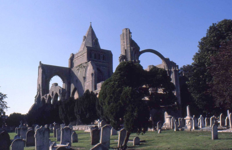
The remains of the Benedictine abbey lie on the south east edge of the old
town, in and around the parish churchyard of SS Mary, Guthlac and
Bartholomew. The parish church occupies the north aisle of the medieval abbey
church, which was a cruciform building of limestone ashlar with Purbeck marble
dressings. Adjoining the west tower of the present church are the standing
remains of the west front of the former nave, a Norman structure altered in
the 13th and 15th centuries. The facade, which rests on a moulded plinth, is
divided into three zones separated by string-courses. The lowest zone is
largely of 13th century construction and includes the central west doorway of
the abbey church, a large pointed opening comprising two smaller pointed
arches with the remains of tracery. The tympanum rests on a trumeau (vertical
stone pillar) which was renewed in the 19th century, and is sculpted with
scrolled foliage around a quatrefoil panel depicting scenes from the life of
St Guthlac. Over the doorway is a hood-mould terminating at each
end in a sculpted head. The jambs are deeply moulded and have marble columns.
To each side of the doorway is a tall, blind trefoil-headed arch, that to the
north containing the remains of a sculpted figure on a pedestal, that to the
south with a pedestal only. Between each arch and the doorway is a small
canopied niche without a figure, although that to the south retains a
pedestal. Below each of these niches is a further canopied niche, that to the
north containing the remains of a sculpted figure on a pedestal, that to the
south a pedestal only. Above the north side of the doorway is a partially
blocked quatrefoil.
The middle zone of the nave facade is occupied by the great west window, a
13th century opening enlarged in the 15th century. To each side is a tall
arched panel containing a quatrefoil above four figures on pedestals, ranged
in two tiers of paired niches, the lowest tier being composed of foliated
canopies. The figures are largely complete. The uppermost zone is of the 15th
century and contains the upper part of the west window, including a
four-centred arch and the remains of Perpendicular tracery. To each side of
the window is a further pair of tall, blind arches containing four figures in
two tiers of niches. Running up from the northern spandrel of the window arch
are three further niches, arranged in steps, also containing figures; the
remains of three similar niches survive in a corresponding position to the
south. Above the surviving niches and below the string-course is a sculpted
frieze of human and animal heads.
Adjoining the southern end of the west front of the nave is a large
15th-century buttress with three tiers of blind panelled tracery, a tall
pinnacle with a small flying buttress at the top, and a fragmentary cusped
frieze below. This buttress is built onto an earlier, shallower buttress which
forms part of the decorative scheme of the pre-15th century facade of the
abbey church. The earlier buttress, of the Norman period, is composed of
vertical panels, some of the columns of which are visible at its north eastern
corner; it terminates near the top of the middle zone of the nave facade, thus
indicating the approximate height of the main vessel of the church before it
was raised in the 15th century. The later buttress is relatively large and
includes, in its northern face, a blocked window and doorway composed of
reused architectural fragments. The doorway is made up of a four-centred arch
with renewed jambs, the hood-mould having been cut away to lie flush with the
wall. To the lower right of the doorway is a row of blind quatrefoil panels
taken from a frieze. The blocked window, above and to the west of the
doorway, is made up of a variety of voussoirs fitting into an irregular
pointed arch. These features are considered to represent the remains of a
late medieval reconstruction of the cell of St Guthlac on its traditional
site outside the western end of the south aisle.
Adjoining the buttress to the south are the ruins of the west front of the
south aisle of the abbey church. This wall, composed of a stepped plinth and
four tiers of roundheaded blind arcading, represents part of the earlier,
Norman fabric of the church. On the east side of the wall is a blind
roundheaded arch; on the south side is an area of rough stonework where the
aisle was bonded into the monastic buildings to the south. The location of the
south wall of the south aisle is marked by a modern retaining wall which is
partly composed of reused fragments from the superstructure.
On the eastern side of the nave facade is the rounded arch of the central
doorway with a blank quatrefoil in the tympanum. To each side of the doorway
is a blind pointed arch; set upright in the northern arch is an early
15th century tombstone. In the interior of the nave, now ruined, are the
remains of the 14th century arcade which stood between it and the south aisle.
The three westernmost piers survive, forming three pointed arches with the
remains of the triforium above. The remains of the fourth and eighth piers
from the west are also evident and survive to a height of about 10m. The
eighth pier has a slot on the northern face where a former screen was
attached. The foundation of the fourth pier is exposed, revealing that Norman
pillar fragments were reused to support the later arcade. The springing for
the nave vault is visible at the western end of the arcade.
The north arcade of the abbey church (which is identical in type and date to
the ruined south arcade) was blocked in 1743 when the parish church was
reduced in size to occupy the former north aisle. From the south side of the
arcade spring further supports for the two westernmost bays of the nave vault.
Adjoining the east end of this arcade are the ruins of the central crossing of
the abbey church, including a large, semi-circular arch which formerly
supported the west wall of the central tower. The south west pier of the
crossing contains a newel staircase giving access to the tower and triforium
walk of which fragments remain. Attached to each end of the surviving arch are
the remains of the arches which stood between the transepts and the aisles.
All of these arches are composed of Norman zig-zag, and further Norman
ornament is visible on the capitals. Fragments of Norman and Gothic arches are
also built into the post-Dissolution panelled buttresses at the eastern end of
the nave.
Built into the bottom of the surviving crossing arch are the remains of a
14th century stone screen, moved here from the east end of the abbey church
when it was demolished at the Dissolution. The screen takes the form of a
solid stone wall with a pointed doorway at each end and a later quatrefoil
frieze above. The east side of the screen, which in its original position
would have faced west, is carved with decorated panels and quatrefoils, and
there is a shallow recess at the centre for a retable (a carved screen behind
the altar). This face has been discoloured by fire in the post-medieval
period. To the west of the screen is the high altar, also moved from the east
end of the monastic church, set on a raised platform paved with post-medieval
gravestones. The interior of the nave and south aisle, which occupies an area
approximately 42m x 16m, was used for burials during the 18th and 19th
centuries; the nave has since been cleared and the ground lowered to its late
medieval level, while the south aisle is still occupied by graves and yew
trees and is consequently higher.
Surrounding the standing remains of the abbey church is a rectangular
churchyard, bounded by a low stone wall, within which lie further remains of
the medieval monastic complex. Beyond the east end of the nave is an area of
low earthworks including a square raised area on the site of the tower and
crossing of the abbey church. To the north and south are the buried remains of
the transepts, and to the east those of the choir. The east end took the form
of a semi-circular apse and was the original site of the medieval altar over
which the shrine of St Guthlac was installed. To the south of the abbey
church, still within the present churchyard, lie the buried remains of the
medieval monastic buildings. These include the cloister, which adjoined the
south wall of the south aisle, the chapter house, which adjoined the south
transept, and the other buildings of the east range, the south range,
including the frater and kitchen, the west range, including the abbot's
lodging, stables and guesthouse set around an inner court, and many other
monastery buildings, including the lay brothers' hall, brewhouse, bakehouse,
workshops and infirmary. These buildings, begun in the late tenth century,
were extensively added to and rebuilt, particularly during the late 15th
century. Finds made during grave-digging in this area include timber and the
remains of hearths.
To the east and south of the churchyard, on a slightly lower level, is a grass
field known as the Kissing Ground. In the south west part of this field are
the low earthworks of a rectangular building aligned north-south. Geophysical
survey in the field has detected the buried remains of further structures.
These have been interpreted as further remains of the monastic complex. Also
within this field, running along the edge of the churchyard wall, is a
shallow, dry ditch up to 1m deep; in the eastern part of the field are further
banks and ditches which form a series of depressions and raised areas crossed
by a later trackway. This is the site of part of a defensive fieldwork
constructed in the Civil War when the church was used as a Royalist
stronghold. The fieldwork was constructed of banks and ditches and took the
form of a defensive rampart around the churchyard with projecting bastions.
Excluded from the scheduling are the walls and fabric of the present parish
church and its tower, though not the ruins attached to them; the churchyard
walls and gateways, which are Listed Grade II; and all gravestones, 161 of
which are Listed Grade II; the ground beneath these features is, however,
included. In the south western part of the churchyard, which is still in use
as a cemetery, the graves, gravestones and earth to a depth of 2m, are
excluded from the scheduling although the ground beneath this depth is
included.
MAP EXTRACT
The site of the monument is shown on the attached map extract.
Source: Historic England
From the time of St Augustine's mission to re-establish Christianity in AD 597
to the reign of Henry VIII, monasticism formed an important facet of both
religious and secular life in the British Isles. Settlements of religious
communities, including monasteries, were built to house communities of monks,
canons (priests), and sometimes lay-brothers, living a common life of
religious observance under some form of systematic discipline. It is estimated
from documentary evidence that over 700 monasteries were founded in England.
These ranged in size from major communities with several hundred members to
tiny establishments with a handful of brethren. They belonged to a wide
variety of different religious orders, each with its own philosophy. As a
result, they vary considerably in the detail of their appearance and layout,
although all possess the basic elements of church, domestic accommodation for
the community, and work buildings. Monasteries were inextricably woven into
the fabric of medieval society, acting not only as centres of worship,
learning and charity, but also, because of the vast landholdings of some
orders, as centres of immense wealth and political influence. They were
established in all parts of England, some in towns and others in the remotest
of areas. Many monasteries acted as the foci of wide networks including parish
churches, almshouses, hospitals, farming estates and tenant villages.
Benedictine monasticism had its roots in the rule written about AD 530 by St
Benedict of Nursia for his own abbey at Monte Cassino. Benedict had not
intended to establish an order of monasteries and wider adoption of his rule
came only gradually. The first real attempt to form a Benedictine order came
only in 1216. The Benedictine monks, who wore dark robes, came to be known as
`black monks'. These dark robes distinguished them from Cistercian monks who
became known as `white monks' on account of their light coloured robes. Over
150 Benedictine monasteries were founded in England. As members of a highly
successful order many Benedictine houses became extremely wealthy and
influential. Their wealth can frequently be seen in the scale and flamboyance
of their buildings. Benedictine monasteries made a major contribution to many
facets of medieval life and all examples exhibiting significant surviving
archaeological remains are worthy of protection.
Documentary sources indicate the existence of 65 pre-Conquest monasteries in
England. The original number of sites is likely to have been slightly higher
and would have included sites for which no documentary reference survives. Of
these, less than 15 can at present be linked to a specific site. Early
monasteries are a rare monument type and one which made a major contribution
to the development of Anglo-Saxon England.
Crowland Abbey was an important pre-Conquest foundation which became highly
influential in the economy and administration of the fenlands in medieval
times. Its connection with the hermitage and relics of the Anglo-Saxon saint,
Guthlac, ensured its position as one of England's important pilgrimage centres
and has contributed to the quantity of historical documentation available for
the site. The remains of the Benedictine abbey, which succeeded the
Anglo-Saxon monastery, survive well. They include not only important
below-ground remains, which have been only superficially damaged by subsequent
grave-digging, but also major upstanding ruins including a famous cycle of
sculpture. Small-scale excavation in the area of the abbey church has
demonstrated the survival of buried architectural remains. The potential for
the retrieval of prehistoric, Roman and early Saxon remains, sealed beneath
those of the medieval period, has been indicated by documentary and
archaeological research in the area. Post-medieval activity on the site has
been of limited impact, with the exception of the Civil War fieldwork which is
a major earthwork structure and of importance in its own right.
Source: Historic England
Books and journals
Attwater, D, The Penguin Dictionary of Saints, (1983), 160-161
Gresley, P, The Fortification made round Croyland Abbey in the...civil Wars, (1856)
Knowles, D , Medieval Religious Houses: England and Wales, (1971), 53-471
Knowles, D , Medieval Religious Houses: England and Wales, (1971), 53-63
Page, W, The Victoria History of the County of Lincolnshire: Volume II, (1906), 105-118
Pevsner, N, John, H, The Buildings of England: Lincolnshire, (1964), 503-507
Hayes, P P, Lane, T W, 'East Anglian Archaeology' in Lincolnshire Survey, The South-West Fens, (1992), 192
Hayes, P P, Lane, T W, 'East Anglian Archaeology' in Lincolnshire Survey, The South-West Fens, (1992), 192
Stocker, D, 'Pre-Viking Lindsey' in The Early Church in Lincolnshire, (1993)
Other
correspondence ref. HSD9/2/842, Department of the Environment, Proposed Works at Crowland Abbey, Crowland, Lincolnshire, (1987)
Listed Building description, Department of the Environment, Crowland Abbey [ref. TF 2410-2510 18/4], (1967)
Reverend Crust, (1992)
Stocker, DA, The Early Church in Lincolnshire, 1993, forthcoming
Swift, Rev. Stanley, A Visitor's Guide to Croyland Abbey and Trinity Bridge, 1992, Official Guide
Swift, Rev. Stanley, Visitor's Guide to Croyland Abbey and Trinity Bridge, 1992, Official Guide
Source: Historic England
Other nearby scheduled monuments