Approximate Location Map
Large Map »
This site is entirely user-supported. See how you can help.
Latitude: 51.1842 / 51°11'2"N
Longitude: -1.8327 / 1°49'57"W
OS Eastings: 411788.710007
OS Northings: 142782.989654
OS Grid: SU117427
Mapcode National: GBR 3YH.RGW
Mapcode Global: VHB5B.5HZL
Entry Name: A bowl barrow and three bell barrows forming part of The Cursus round barrow cemetery
Scheduled Date: 10 March 1925
Last Amended: 1 May 1995
Source: Historic England
Source ID: 1012401
English Heritage Legacy ID: 10342
County: Wiltshire
Civil Parish: Durrington
Traditional County: Wiltshire
Lieutenancy Area (Ceremonial County): Wiltshire
Church of England Parish: Amesbury St Mary and St Melor
Church of England Diocese: Salisbury
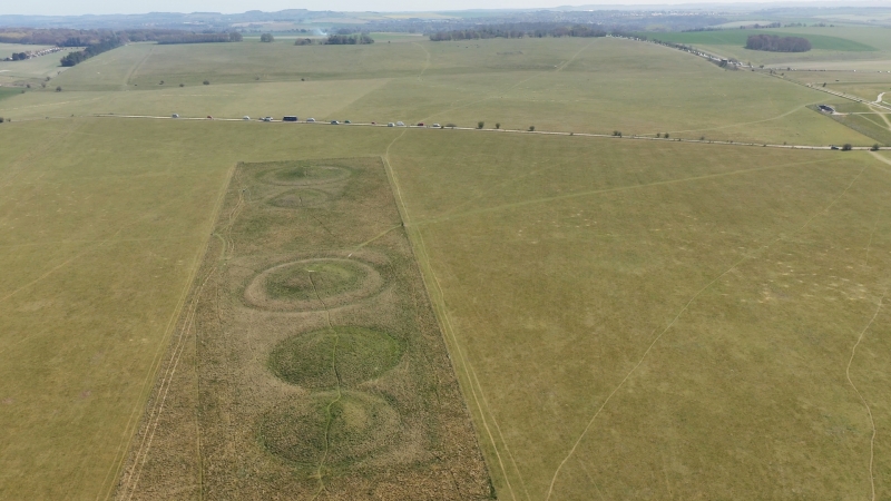
The monument includes four round barrows forming part of the Cursus round
barrow cemetery, situated south of the Cursus on an east west ridge with views
across Stonehenge to Normanton Down. The Cursus round barrow cemetery contains
16 round barrows in all, including seven bowl barrows, six bell barrows, a
twin bell barrow and a disc barrow.
This monument contains one of the bowl barrows and three of the bell barrows.
The western barrow is a bowl barrow 0.5m high and 43m in overall diameter
including an outer bank which survives as a slight earthwork 4m wide and 0.2m
high. Some 30m to the east is a pair of confluent bell barrows with overall
diameters of 36m and 38m. The mounds are each 20m in diameter and 2m high, and
positioned eccentrically. Some 10m further east is a large bell barrow, the
mound of which is 28m in diameter and 3.5m high, surrounded by a berm and
outer ditch and having an overall diameter of 56m.
All four barrows were partially excavated in the 19th century, each revealing
a primary cremation, one accompanied by a bronze dagger, another by beads of
amber, stone and faience.
All fence posts are excluded from the scheduling but the ground beneath these
features is included.
MAP EXTRACT
The site of the monument is shown on the attached map extract.
It includes a 2 metre boundary around the archaeological features,
considered to be essential for the monument's support and preservation.
Source: Historic England
A small number of areas in southern England appear to have acted as foci for
ceremonial and ritual activity during the Neolithic and Bronze Age periods.
Two of the best known and earliest recognised areas are around Avebury and
Stonehenge, now jointly designated as a World Heritage Site.
The area of chalk downland which surrounds Stonehenge contains one of the
densest and most varied groups of Neolithic and Bronze Age field monuments in
Britain. Included within the area are Stonehenge itself, the Stonehenge
cursus, the Durrington Walls henge, and a variety of burial monuments, many
grouped into cemeteries.
The area has been the subject of archaeological research since the 18th
century when Stukeley recorded many of the monuments and partially excavated a
number of the burial mounds. More recently, the collection of artefacts from
the surfaces of ploughed fields has supplemented the evidence for ritual and
burial by revealing the intensity of contemporary settlement and land-use. In
view of the importance of the area, all ceremonial and sepulchral monuments of
this period which retain significant archaeological remains are identified as
nationally important.
Round barrow cemeteries date to the Bronze Age (2000-700 BC). They comprise
closely spaced groups of up to 30 round barrows - rubble or earthen mounds
covering single or multiple burials. Most cemeteries developed over a
considerable period of time, often many centuries, and in some cases acted as
a focus for burials as late as the early medieval period. They exhibit
considerable diversity of burial rite, plan and form, frequently including
several different types of round barrow and occasionally associated with
earlier long barrows. Where investigation beyond the round barrows has
occurred, contemporary or later 'flat' burials between the barrow mounds have
often been revealed. Round barrow cemeteries occur across most of lowland
England with a marked concentration in Wessex. In some cases they are
clustered around other important contemporary monuments, as is the case both
here and at Avebury. Often occupying prominent positions, they are a major
historic element in the modern landscape, while their diversity and their
longevity as a monument type provide important information on the variety of
beliefs and social organisation amongst early prehistoric communities.
Bell barrows, the most visually impressive form of round barrow, are funerary
monuments dating from 1600-1200 BC. They occur either in isolation or in
round barrow cemeteries. They were constructed as single or multiple mounds
covering burials often in pits and surrounded by an enclosure ditch. The
burials in bell barrows appear to be those of aristocratic individuals and are
also frequently accompanied by weapons, personal ornaments and pottery
vessels. Bell barrows are rare nationally with only 250 examples known of
which 30 are located within the Stonehenge area.
Bowl barrows, the most numerous form of round barrow, are funerary monuments
dating from the Late Neolithic period to the Late Bronze Age. They were
constructed as earthen or rubble mounds, normally ditched, which covered
single or multiple burials. Often superficially similar, although differing
widely in size, they exhibit regional variations in form and a variety of
burial practices. The burials, either inhumations or cremations, are sometimes
accompanied by pottery vessels, tools and personal ornaments. There are over
10,000 surviving bowl barrows recorded nationally and at least 320 in the
Stonehenge area.
The bowl barrow and three bell barrows situated south of the Cursus and
forming the eastern part of the Cursus round barrow cemetery survive well and
are known from partial excavation to contain archaeological remains and
environmental evidence relating to the monument and the landscape in which it
was constructed.
Source: Historic England
Books and journals
Grinsell, LV, The Victoria History of the County of Wiltshire: Volume V, (1957), 207
Grinsell, LV, The Victoria History of the County of Wiltshire: Volume V, (1957), 207
Grinsell, LV, The Victoria History of the County of Wiltshire: Volume V, (1957), 207
Grinsell, LV, The Victoria History of the County of Wiltshire: Volume V, (1957), 205
Hoare, R C, Ancient History of Wiltshire, (1812), 162-163
Hoare, R C, Ancient History of Wiltshire, (1812), 162
Source: Historic England
Other nearby scheduled monuments