Approximate Location Map
Large Map »
This site is entirely user-supported. See how you can help.
Latitude: 52.5242 / 52°31'27"N
Longitude: -0.4357 / 0°26'8"W
OS Eastings: 506226.471378
OS Northings: 292968.1003
OS Grid: TL062929
Mapcode National: GBR FXC.QNK
Mapcode Global: VHFNB.DTJ9
Entry Name: Fotheringhay motte and bailey castle
Scheduled Date: 9 October 1981
Last Amended: 3 September 1992
Source: Historic England
Source ID: 1012072
English Heritage Legacy ID: 13641
County: Northamptonshire
Civil Parish: Fotheringhay
Traditional County: Northamptonshire
Lieutenancy Area (Ceremonial County): Northamptonshire
Church of England Parish: Fotheringhay St Mary the Virgin and All Saints
Church of England Diocese: Peterborough
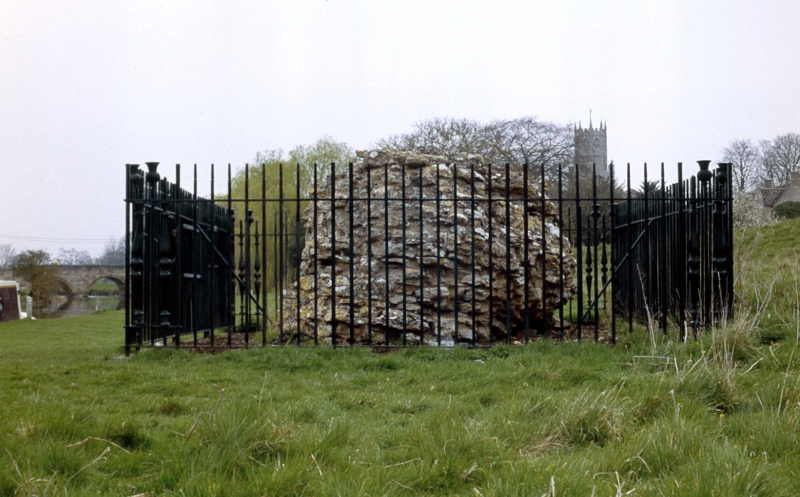
The motte and bailey castle at Fotheringhay lies at the south eastern end of
the present village close to the River Nene. The castle consists of a
substantial earthwork motte, an inner bailey and the remains of the
outer bailey earthworks.
The motte is a steep-sided round mound approximately 7m high and about 70m in
diameter. The top of the mound is flattened and about 30m across with an
irregular surface, indicating the remains of the stone keep. A ditch up to
4m deep and 20m wide is visible on the north and west sides of the motte.
Originally this ditch is thought to have encircled the mound. A ditch of
similar size surrounds the inner and outer bailey areas. The inner bailey is
sub-rectangular and measures about 50m x 65m and retains traces of an
earthern rampart. At the north east corner of the outer bailey near the river
are the remains of a sluice gate associated with the water management system
of the bailey ditches. The outer bailey ditch on the north and west sides has
been largely infilled.
The castle is considered to have been built by Simon de St Liz, Earl of
Huntingdon and Northampton, who married Judith, a niece of William the
Conqueror. From the late 13th century the castle took on the dual role of
royal palace and state prison. The castle was enlarged and rebuilt in the
late 14th century by Edmund Langley, son of Edward III, and it is thought that
the outer bailey dates from this period, as does the infilling of the east
side of the motte ditch. Records indicate that in 1341 a stone tower stood on
the motte, and within the inner bailey were two chapels, a great hall,
chambers and a kitchen. A gatehouse stood beside a drawbridge over the inner
bailey ditch. A further gatehouse existed in the north west corner of the
outer bailey, and a group of buildings known as The Manor lay north west of
the motte on the site of Castle Farm.
Mary Queen of Scots was imprisoned in the castle in 1586, and eventually
executed there in 1587. The castle was abandoned in the 17th century and by
the early 18th century was demolished. In the 19th century the moat on the
west side was infilled.
Castle Farm, all farm buildings, agricultural installations, made up roadways
and paths on the site are excluded from the scheduling, but the ground beneath
is included.
MAP EXTRACT
The site of the monument is shown on the attached map extract.
Source: Historic England
Motte castles are medieval fortifications introduced into Britain by the
Normans. They comprised a large conical mound of earth or rubble, the motte,
surmounted by a palisade and a stone or timber tower. In a majority of
examples an embanked enclosure containing additional buildings, the bailey,
adjoined the motte. Motte castles and motte-and-bai1ey castles acted as
garrison forts during offensive military operations, as strongholds, and, in
many cases, as aristocratic residences and as centres of local or royal
administration. Built in towns, villages and open countryside, motte castles
generally occupied strategic positions dominating their immediate locality
and, as a result, are the most visually impressive monuments of the early
post-Conquest period surviving in the modern landscape. Over 600 motte castles
and motte-and-bailey castles are recorded nationally, with examples known from
most regions. Some 100-150 examples do not have baileys and are classified as
motte castles. As one of a restricted range of recognised early post-Conquest
monuments, they are particularly important for the study of Norman Britain and
the development of the feudal system. Although many were occupied for only a
short period of time, motte castles continued to be built and occupied from
the 11th to the 13th centuries, after which they were superseded by other
types of castle.
Fotheringhay Castle is a fine example of a large motte and bailey castle
strategically placed beside a river crossing. The earthworks of the site are
largely undisturbed and documentary evidence indicates that a diversity of
archaeological features are likely to be preserved on the site. The castle
has well documented royal connections from the Norman period and also has
particular historical significance as the prison and execution place of Mary
Queen of Scots.
Source: Historic England
Books and journals
Royal Commission on Historical Monuments of England, , Archaeological Sites in North East Northamptonshire , (1975), 43-6
Source: Historic England
Other nearby scheduled monuments