Approximate Location Map
Large Map »
This site is entirely user-supported. See how you can help.
Latitude: 52.0743 / 52°4'27"N
Longitude: 0.0049 / 0°0'17"E
OS Eastings: 537504.418822
OS Northings: 243663.466752
OS Grid: TL375436
Mapcode National: GBR K7C.VFQ
Mapcode Global: VHHKT.14G6
Entry Name: Bowl barrow, known as Grinnel Hill, 260m SSE of Lodge Cottage
Scheduled Date: 30 November 1925
Last Amended: 25 May 1995
Source: Historic England
Source ID: 1011719
English Heritage Legacy ID: 24424
County: Cambridgeshire
Civil Parish: Melbourn
Traditional County: Cambridgeshire
Lieutenancy Area (Ceremonial County): Cambridgeshire
Church of England Parish: Melbourn
Church of England Diocese: Ely
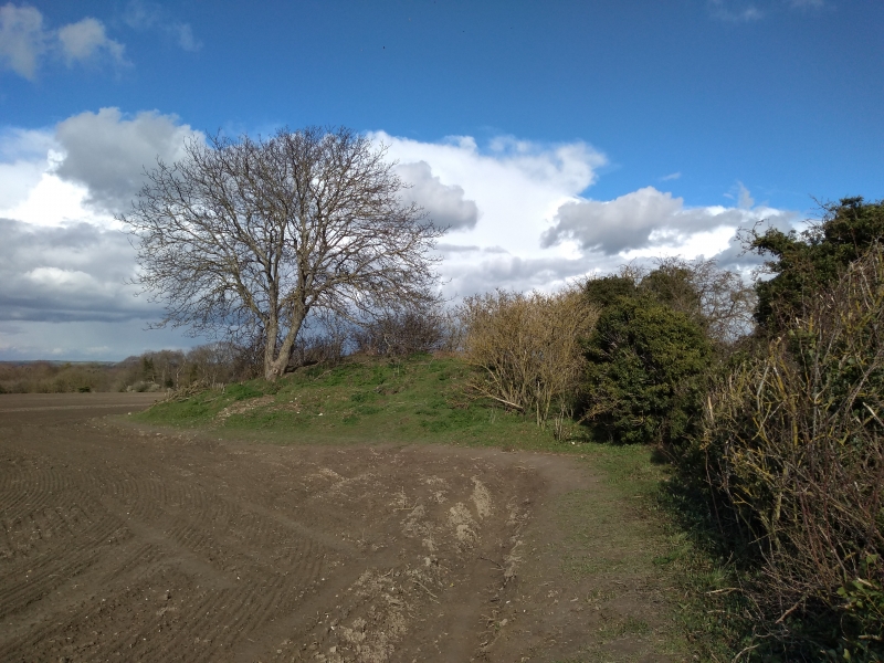
The monument includes a bowl barrow situated in a prominent position on the
northern facing slope of the chalk hills, some 250m to the south of the
Royston Road (formerly the A10). The barrow mound measures 18m east to west
and 22m north to south, and survives to approximately 3m in height. The mound
is thought to have originally been circular in plan, however the profile of
the north eastern side shows evidence of later truncation which has removed
approximately 4m from the width. The steep sloping sides of the mound descend
from a small level area on the summit measuring approximately 8m in diameter.
The barrow, which is apparently unexcavated, forms part of a wider group of
similar monuments which extend across the eastern fringe of the Chiltern Hills
to the north and west of Royston. Many of the more conspicuous barrows were
investigated in the 19th century, including examples at Heath Farm, 2km to the
south, and Therfield Heath, 4km to the south west, and found to contain
archaeological remains dating to the Bronze Age.
MAP EXTRACT
The site of the monument is shown on the attached map extract.
It includes a 2 metre boundary around the archaeological features,
considered to be essential for the monument's support and preservation.
Source: Historic England
Bowl barrows, the most numerous form of round barrow, are funerary monuments
dating from the Late Neolithic period to the Late Bronze Age, with most
examples belonging to the period 2400-1500 BC. They were constructed as
earthen or rubble mounds, sometimes ditched, which covered single or multiple
burials. They occur either in isolation or grouped as cemeteries and often
acted as a focus for burials in later periods. Often superficially similar,
although differing widely in size, they exhibit regional variations in form
and a diversity of burial practices. There are over 10,000 surviving bowl
barrows recorded nationally (many more have already been destroyed), occurring
across most of lowland Britain. Often occupying prominent locations, they are
a major historic element in the modern landscape and their considerable
variation of form and longevity as a monument type provide important
information on the diversity of beliefs and social organisations amongst early
prehistoric communities. They are particularly representative of their period
and a substantial proportion of surviving examples are considered worthy of
protection.
Despite some disturbance caused by the alteration of the north eastern side of
the mound, the bowl barrow known as Grinnel Hill is very well preserved. The
mound stands to approximately its full height, in marked contrast to the
majority of barrows within Cambridgeshire which are now only visible on aerial
photographs. There is no evidence that the barrow has ever been excavated and
archaeological remains (including burials) within the mound will remain
undisturbed affording valuable insights into early burial practice. The former
ground surface, buried beneath the mound, will provide information concerning
the landscape in which it was constructed.
The importance of the monument is enhanced by its association with a wider
group of similar monuments, including the remains of another bowl barrow
situated some 40m to the NNW (the subject of a separate scheduling).
Comparisons between these sites will provide valuable information concerning
the variation and development of prehistoric burial practices.
Source: Historic England
Books and journals
Fox, C, Grinnel Hill Tumulus, (1924)
Neville, R C, Sepulchra Exposita, (1848), 17-27
Other
Stephenson, M, An Initial Survey of Prehistory in the Royston Area, 1980, Undergraduate dissertation
Source: Historic England
Other nearby scheduled monuments