Approximate Location Map
Large Map »
This site is entirely user-supported. See how you can help.
Latitude: 52.0324 / 52°1'56"N
Longitude: -0.9085 / 0°54'30"W
OS Eastings: 474971.870854
OS Northings: 237672.322807
OS Grid: SP749376
Mapcode National: GBR BYR.K45
Mapcode Global: VHDT4.65KS
Entry Name: The Grove Close moated site.
Scheduled Date: 21 January 1992
Source: Historic England
Source ID: 1011015
English Heritage Legacy ID: 13617
County: Northamptonshire
Civil Parish: Wicken
Traditional County: Northamptonshire
Lieutenancy Area (Ceremonial County): Northamptonshire
Church of England Parish: Wicken St John the Evangelist
Church of England Diocese: Peterborough
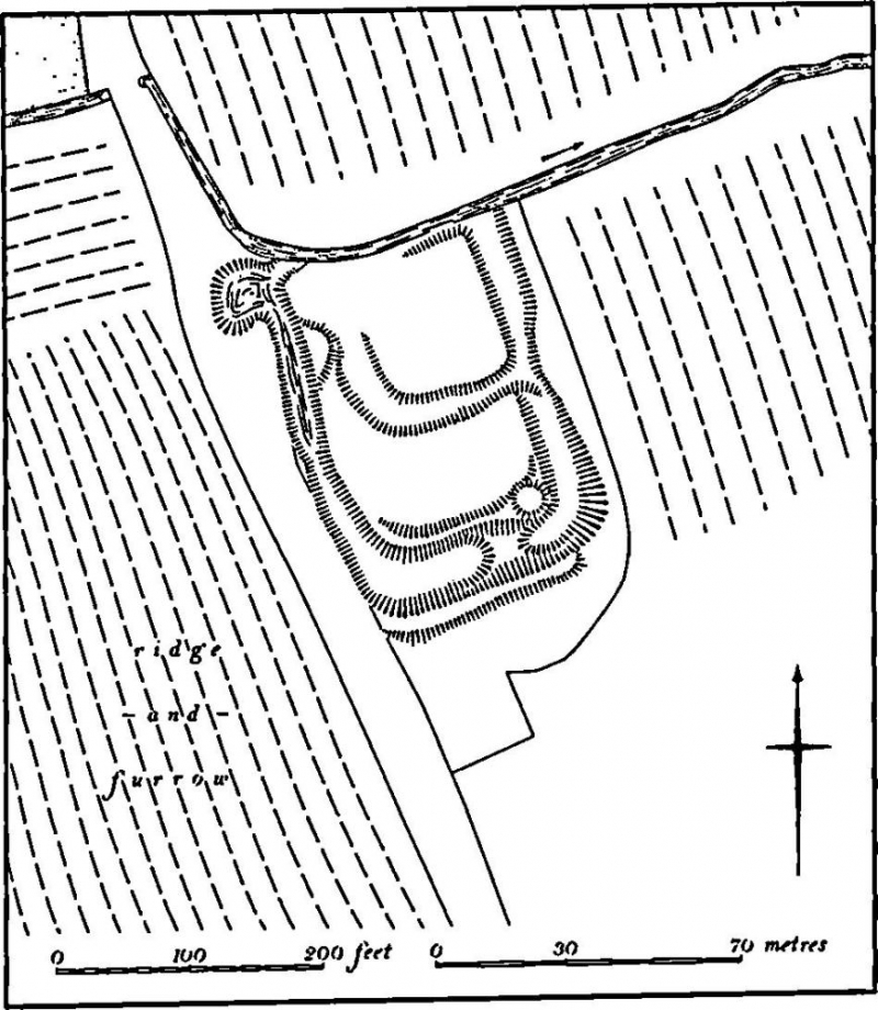
Grove Close moat lies to the south east of Wicken Park and consists of a
rectangular moated site measuring about 88m x 60m. The moat is fed by a small
stream which runs along the north side of the site and three of the four
original moat arms are preserved. Remains of a further ditch 1m deep and 4m
wide crosses the centre of the site from west to east and it is considered
that Grove Close was originally a double moated site. The west arm of the
monument is still waterlogged particularly at its northern end, and is about
4m wide and 1.5m deep. The north arm is about 1m deep and 2m wide and a slight
outer bank is still visible on the north of the site. The east arm varies in
width between 2m and 4m and is about 1m deep. Irregularities in the surface of
the moat island at its southern end mark the remains of buildings, the
presence of which are indicated on early maps of the area.
MAP EXTRACT
The site of the monument is shown on the attached map extract.
Source: Historic England
Around 6,000 moated sites are known in England. They consist of wide ditches,
often or seasonally water-filled, partly or completely enclosing one or more
islands of dry ground on which stood domestic or religious buildings. In some
cases the islands were used for horticulture. The majority of moated sites
served as prestigious aristocratic and seigneurial residences with the
provision of a moat intended as a status symbol rather than a practical
military defence. The peak period during which moated sites were built was
between about 1250 and 1350 and by far the greatest concentration lies in
central and eastern parts of England. However, moated sites were built
throughout the medieval period, are widely scattered throughout England and
exhibit a high level of diversity in their forms and sizes. They form a
significant class of medieval monument and are important for the understanding
of the distribution of wealth and status in the countryside. Many examples
provide conditions favourable to the survival of organic remains.
The Grove Close is an unusual site of double moat plan, and documentary
sources indicate the presence of buildings on one of the moat islands. The
largely undisturbed and waterlogged ditches of the moat have potential for the
preservation of organic remains.
Source: Historic England
Other nearby scheduled monuments