Approximate Location Map
Large Map »
This site is entirely user-supported. See how you can help.
Latitude: 54.9935 / 54°59'36"N
Longitude: -2.4656 / 2°27'56"W
OS Eastings: 370308.977313
OS Northings: 566648.902731
OS Grid: NY703666
Mapcode National: GBR CB7P.0R
Mapcode Global: WH90W.3R57
Entry Name: Great Chesters Roman fort and Hadrian's Wall between the Caw Burn and the track to Cockmount Hill farm in wall miles 42 and 43
Scheduled Date: 12 December 1928
Last Amended: 14 July 1997
Source: Historic England
Source ID: 1010976
English Heritage Legacy ID: 26065
County: Northumberland
Civil Parish: Greenhead
Traditional County: Northumberland
Lieutenancy Area (Ceremonial County): Northumberland
Church of England Parish: Haltwhistle Holy Cross
Church of England Diocese: Newcastle
The monument includes the section of Hadrian's Wall and vallum and the Roman
fort at Great Chesters and their associated features between the Caw Burn in
the east and the track to Cockmount Hill farm in the west.
All the upstanding remains of Hadrian's Wall, the milecastle and turrets are
Listed Grade I.
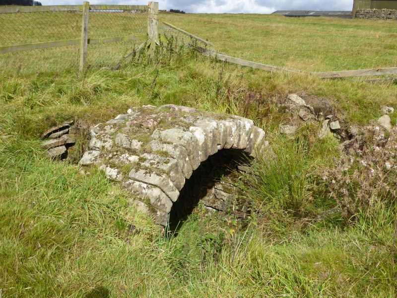
Hadrian's Wall survives as a low stony mound throughout much of this section.
It is visible as a turf-covered scarp 0.2m high with a modern field wall
overlying its course. The farm buildings at Great Chesters east of milecastle
43 partly overlie the Wall in this area. West of Great Chesters fort the
course of the narrow wall survives as an amorphous rubble strewn mound 3m to
4.8m wide and 1.1m high. In addition the line of the broad wall here survives
as a separate north facing scarp. Excavations here in 1925 revealed that the
narrow wall runs south of the broad wall foundation from Great Chesters as far
as turret 43a where they converge. Beyond turret 43a they run parallel again
as far as Cockmount Hill Wood where their courses again converge. To the west
of Burnhead camp a section of unconsolidated exposed Wall, 38m long and 1.8m
wide, stands between two to six courses high being up to 1.5m high on the
inner face. The wall ditch survives a visible earthwork throughout most of
this section. It averages between 0.8m and 2m in depth with near vertical
sides in places. Large boulders protrude from the scarps intermittently along
its length. The ditch at Great Chesters is overlain by farm buildings which
are excluded from the scheduling, although the ground beneath them is
included. The ditch is not visible either side of turret 43a, suggesting that
it has silted up leaving no trace on the surface. The ditch upcast mound,
usually referred to as the `glacis', survives to the west of Great Chesters
fort as a broad low mound, 0.3m high and 8m wide, on the north side of the
wall ditch.
Milecastle 43 is situated on a ridge later occupied by the fort of Great
Chesters which commands views to Chesters Pike in the north, the Stanegate
Roman road to the south and the Caw Burn to the east. The milecastle survives
as a buried feature below the turf cover. It was located during excavation at
Great Chesters in 1939 by Simpson and Richmond.
Turret 42b is situated on a gentle east facing slope to the west of the Caw
Burn. It survives as an uneven turf-covered platform, up to 0.6m high. The
surface remains show evidence of digging and stone robbing. The turret was
first located in 1912 by Simpson.
Turret 43a is thought to be situated about 150m east of Cockmount Hill farm.
There are quantities of wall debris strewn over the grass-covered bank of the
Wall at this location which may obscure any slight surface remains of the
turret. The site of the turret was first suggested in 1912 by Simpson, but its
position has not yet been verified.
The course of the Roman road known as the Military Way, which ran along the
corridor between the Wall and the vallum linking the turrets, milecastles and
forts, survives intermittently as an upstanding feature throughout this
section. Its course from the Caw Burn is known where it survives as a low
turf-covered mound, 6m to 8m wide and 0.2m to 0.5m high. Occasional sections
of this low turf-covered causeway reappear on the line up to the east gateway
of Great Chesters fort. Beyond the field boundary west of the fort the
Military Way is visible again as a discontinuous terrace with a slightly
sinuous course which avoids the rock outcrops. Field gates are positioned on
its course at the east and west end of this stretch. A road linking the
Military Way and the Stanegate Roman road to the south via Great Chesters fort
is overlain by the modern trackway to Great Chesters Farm which enters the
fort through the south gateway.
The vallum survives as an upstanding earthwork in the west half of this
section, but in the east half it is only recognisable as an intermittent mound
and ditch and by occasional discolourations in the vegetation. In the west
half of the section the north mound averages 0.8m high, the ditch 0.5m to 0.9m
deep and the south mound 1.2m high. Here crossings of the vallum are still to
be seen at approximately 37m intervals. An excavation trench was cut across
the vallum in 1939 by Simpson and Richmond at Cockmount Hill, but the precise
location of this trench is not known. It was revealed that a causeway across
the vallum was revetted with turves, and that the sides of the ditch had
already weathered back prior to the building of the causeway, indicating that
the causeway was later.
Between Great Chesters fort and turret 43a are the remains of three separate
shielings abutting the south side of the narrow wall, which survives here as a
turf-covered mound. The shielings are visible as turf-covered dry stone
foundations. Their walls measure between 0.6m and 2.1m wide and up to 0.3m
high. Shielings are small shepherds' huts usually associated with upland
grazing during the summer months. They are characteristic of the medieval
period in this area.
Great Chesters Roman fort, known to the Romans as Aesica, is situated on a low
ridge overlooking the Caw Burn to the west. It measures 129m by 109m across
its ramparts and encloses an area of 1.36ha. It was one of the last forts to
be built, being attached to the rear of the Wall, like Carrawburgh, and
was completed between AD 128 and AD 138. It is visible as a series of
upstanding turf-covered remains. The most obvious features are the turf-
covered ramparts and the defence ditches, there being no less than four on the
most vulnerable west side. The buildings of Great Chesters farm overlie the
north east corner of the fort. There have been a number of excavations of the
fort, all of which have now been backfilled leaving amorphous mounds and
depressions on the ground surface. These excavations have recorded the remains
of the headquarters building, commanding officer's house, barrack blocks and
lean-to structures against the inside of the fort walls. A vaulted chamber was
discovered in the headquarters building which is on display in the centre of
the fort. The west tower of the south gate has yielded an important hoard of
jewellery which includes an enamelled brooch shaped as a hare and a gilded
bronze brooch considered to be a masterpiece of Celtic art. A number of stone
ballista balls were found beside the north west angle-tower when first
excavated in 1894. A number of building inscriptions have also been
discovered.
Traces of the civil settlement outside the fort, usually referred to as the
vicus, have been identified to the south and east of the fort. Horsley,
writing in 1732, mentioned that, `the outbuildings are most considerable to
the south side....there are vast ruins of buildings in this field'. There is
a series of building platforms terraced into the slope to the south east of
the fort either side of a long scarp running from the south east corner of the
fort to the bath house. The most prominent platform contains a section of
upstanding exposed walling. The field to the south of the fort has been
ploughed for many years and there are no upstanding features visible except
for a slight platform close to the field wall south of the fort. However,
bearing in mind the examples of the better known vicus sites at Housesteads
and Vindolanda it is expected that the vicus remains at Great Chesters will
survive as buried features in the field to the south of the fort and possibly
more extensively.
The remains of a bath house 110m due south of the south east angle of the fort
were visible until the end of 1987 when they were back filled to the
surrounding ground level by English Heritage to avoid further deterioration.
The bath house was excavated in 1897 by Gibson and again in 1908 by Simpson
and Gibson. The excavations showed that it conformed to the usual design of
military bath houses with the various hot, cold and intermediate rooms,
together with furnaces, flues and a hypocaust system. It survives as a buried
feature.
The exact location and extent of the cemeteries directly associated with this
fort are not yet confirmed with certainty. There are two cemeteries to the
south of the vallum; one at Wall Mill and one at Four Laws, both of which are
the subject of separate schedulings. However, a burial mound is located
approximately 240m south west of the fort. This round burial mound is similar
in form to burial mounds found near Housesteads and Vindolanda. Together
with a number of inscribed tombstones found during excavation of the fort
interior it seems that there was a cemetery associated with Great Chesters to
the south of the vicus and north of the vallum in addition to the known
cemeteries at Wall Mill and Four Laws.
There is a series of cultivation terraces running parallel with the contours
approximately 350m west of the fort. There are at least six terraces
identifiable in this group all of which survive as upstanding turf-covered
earthworks. They are directly comparable to the examples at Housesteads which
have been confirmed as Roman in date, which like these are also situated on a
south facing slope. Some of these cultivation terraces are overlain by post-
medieval narrow ridge and furrow indicating a succession of land use in this
area over time.
All field boundaries, except those constructed directly on the line of
Hadrian's Wall, road and track surfaces and buildings, including Great
Chesters farmhouse which is Listed Grade II, are excluded from the scheduling,
but the ground beneath all these features is included.
MAP EXTRACT
The site of the monument is shown on the attached map extract.
It includes a 5 metre boundary around the archaeological features,
considered to be essential for the monument's support and preservation.
Source: Historic England
Hadrian's Wall marks one of the frontiers of the Roman Empire. The
international importance of the surviving remains has been recognised through
designation as a World Heritage Site.
The military importance of the Tyne-Solway route across the Pennines was
recognised by the Romans during their early campaigns through northern England
and into Scotland in the second half of the first century AD. At this time a
military road, the Stanegate, was constructed along with a series of forts.
Subsequently the Romans largely withdrew from Scotland and there is evidence
that the Tyne-Solway route was being recognised as a frontier by the start of
the second century AD. This position was consolidated in the early second
century by the construction of a substantial frontier work, Hadrian's Wall,
under the orders of the Emperor Hadrian. Hadrian's successor, Antoninus Pius,
subsequently attempted to establish the boundary further north, between the
Clyde and the Firth of Forth, but by c.AD 160 growing unrest amongst the
native populations of northern Britain and pressures elsewhere in the Empire
caused a retraction back to the Hadrianic line. Hadrian's Wall was then the
frontier of the Roman Empire in Britain until c.AD 400 when the Roman armies
withdrew from Britain.
Stretching over 70 miles from coast to coast, Hadrian's Wall was a continuous
barrier built of stone in the east and, initially, of turf in the west. The
stone wall was originally designed to be ten Roman feet wide and sections of
this width are termed broad wall. A change of plan shortly after construction
began led to a reduction in the width of the Wall to eight Roman feet, such
sections being termed narrow wall. Today, stretches of both wall types
survive, including some sections of narrow wall built on broad wall
foundations. For most of its length a substantial ditch on the northern side
provided additional defence. Where the Wall crossed rivers, bridges were
constructed to carry it across. Construction of the Wall was organised and
executed by legionary soldiers. From the beginning the barrier was planned to
comprise more than just a curtain wall. At regularly spaced intervals of about
a mile along its length lay small walled fortlets known as milecastles. These
were attached to the southern side of the Wall and most had a gateway through
the Wall to the north. Hence they controlled crossing points through the Wall
as well as affording space for a small stable garrison. Between the
milecastles were two equally spaced towers known as turrets. Together the
milecastles and turrets provided bases from which the curtain wall could be
watched and patrolled. Both the turrets and milecastles are thought to have
been higher than the Wall itself to provide suitable observation points. It is
often assumed that a platform existed on the Wall so that troops could
actually patrol along the wall top; it is however far from certain that this
was the case.
At the western end of the Wall a system of towers, small fortlets and palisade
fences extended the frontier system another 30 miles or so down the Cumbrian
coast and helped control shipping moving across the estuary of the Solway
Firth.
As originally planned, and apart from whatever space there was in the
milecastles, provision for the accommodation of garrison troops manning the
Wall was left with the line of forts which already lay along the Stanegate. At
some point a fundamental change of plan took place and forts were constructed
along the line of the Wall itself. There are now known to have been 16 forts
either attached to the Wall or in close association with it. Some overlay
earlier features such as turrets or milecastles. At this stage another linear
element, the vallum, was also added to the defensive system to the south of
the Wall. This was a broad flat-bottomed ditch flanked by a pair of linear
banks. It shadows the course of the Wall for almost all its length, sometimes
lying very close to it but sometimes up to a kilometre away from it. The
vallum's main function was to act as a barrier to restrict access to the Wall
from the south. It also had a function in linking the forts along the Wall
with a method of lateral communication. When the forts were placed along the
wall line no provision was made for a road to link them. This situation was
clearly found impracticable and a metalled track was therefore provided in
places along the vallum between the north mound and the ditch.
Later, after the withdrawal back to the Hadrianic line from the Antonine Wall,
various refurbishments were made throughout the frontier line. At this stage a
new linear feature was added: the `Military Way'. This was a road linking all
elements of the Wall defence, running from fort to fort within the area
bounded by the Wall and the vallum.
Throughout its long history the Wall was not always well maintained. It was
often neglected and sometimes overrun, but it remained in use until the late
fourth century when a weak and divided Roman Empire finally withdrew its
armies from the Wall and Britain.
It now survives in various states of preservation. In places, especially in
the central section, the Stone Wall still remains several courses high and the
attached forts, turrets and milecastles are also clearly identifiable.
Earthwork features such as the ditch, vallum and Military Way also survive
well in places. Elsewhere the Stone Wall has been virtually robbed out and
only its foundations survive beneath the present ground surface. Similarly,
stretches of the earthwork remains, including sections of the Turf Wall, have
been levelled or infilled and now only survive as buried features. Although
some sections of the frontier system no longer survive visibly, sufficient
evidence does exist for its position to be fairly accurately identified
throughout most of its length.
Whilst all the forts added to the Wall are broadly similar in size, no two are
exactly alike and there is no standard internal layout. However, when
originally built, all forts enclosed a fairly standard range of buildings
including a headquarters building, commandant's house, hospital, barracks,
stables, granaries and workshops. The size and number of barracks blocks has,
in the past, been used to determine the size and type of military unit
stationed there. This is a difficult exercise which remains the subject of
much debate. The area outside the fort was put to a variety of uses. There was
usually a bath house and normally a number of temples, burial grounds and
other official establishments such as lodging houses for official visitors.
Over time sprawling external settlements known as vici grew up around many
forts. These housed a range of people and activities attracted by the military
presence. Some of the inhabitants may have been families of troops stationed
on the Wall, although it was not until the third century that soldiers on
active duty were officially permitted to marry. Others may have been retired
soldiers and their families. Traders and merchants are also thought to have
set up workshops and shops in the vici. The most common type of building found
here, as well as in other areas around forts, was the long narrow strip
building. These appear to have been used for both domestic and commercial
purposes.
Great Chesters Roman fort and Hadrian's Wall between the Caw Burn and the
track to Cockmount Hill farm survive well as a series of upstanding and buried
remains. Significant information on the development of the frontier system
over time will be preserved. The silted ditches will contain environmental
evidence which will allow the character of the surrounding area in the Roman
period to be better understood.
Source: Historic England
Books and journals
Bruce, J C, Handbook to the Roman wall, (1863), 179-183
Richmond, I A, 'Journal of Roman Studies' in Roman Britain in 1949, , Vol. 40, (1950), 164-5
Source: Historic England
Other nearby scheduled monuments