Approximate Location Map
Large Map »
This site is entirely user-supported. See how you can help.
Latitude: 51.2104 / 51°12'37"N
Longitude: -2.1455 / 2°8'43"W
OS Eastings: 389929.490471
OS Northings: 145695.074828
OS Grid: ST899456
Mapcode National: GBR 1V7.4C7
Mapcode Global: VH97H.RVL0
Entry Name: Battlesbury Camp Monuments: hillfort, settlement, cemetery, barrows, enclosure, and field systems
Scheduled Date: 9 October 1981
Last Amended: 12 March 1990
Source: Historic England
Source ID: 1010195
English Heritage Legacy ID: 10081
County: Wiltshire
Civil Parish: Warminster
Built-Up Area: Warminster
Traditional County: Wiltshire
Lieutenancy Area (Ceremonial County): Wiltshire
Church of England Parish: Warminster St Denys
Church of England Diocese: Salisbury
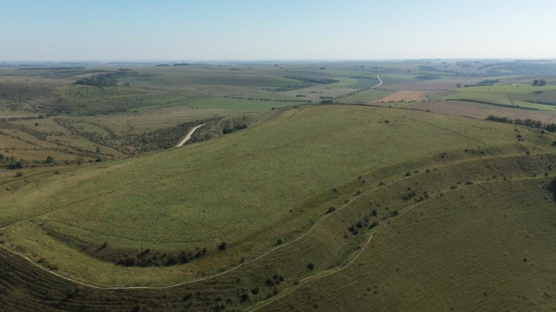
The scheduled area includes an Iron Age hillfort, an unenclosed Iron Age
settlement, a cemetery, three bowl barrows, a field system and enclosure
within the hillfort, and two strip lynchet systems outside the hill fort.
1 - An Iron Age hillfort with a double row of earthen defences enclosing an
area of c.10 hectares. There are entrances in the east and north-west.
2 - An area of Iron Age settlement to the north of Battlesbury Camp hillfort.
Partial excavation in the 1950's revealed traces of postholes and pits which
contained animal bones and pottery.
3 - An inhumation cemetery near the north-west entrance of Battlesbury Camp
hillfort. Several human skeletons, skulls and part of a horse skeleton have
been found at various times. The cemetery is considered to be of Iron Age
date.
4 - A strip lynchet field system lying on the slopes to the south-east of
Battlesbury Camp hillfort. The lynchets are up to 2m high.
5 - A strip lynchet field system lying on the slopes to the north-east of
Battlesbury Camp hillfort. The lynchets are over 2m high in places.
6 - A small Bronze Age bowl barrow partly overlain by the outer defences of
Battlesbury Camp hillfort. Partial excavations in the 19th century produced a
primary cremation and two secondary skeletons. (ST89784543)
7 - A Bronze Age bowl barrow lying between the inner and outer defences of
Battlesbury Camp hillfort. Partial excavations in the 19th century produced no
finds. It has been suggested this feature may be a windmill stance or a small
motte. (ST89804545)
8 - A small Bronze Age bowl barrow partly overlain by the outer defences of
Battlesbury Camp hillfort. Partial excavations in the 19th century produced a
cremation. (ST89794544)
9 - A small circular enclosure within Battlesbury Camp hillfort. (ST89934562)
10 - Traces of field system inside Battlesbury Camp hillfort.
MAP EXTRACT
The site of the monument is shown on the attached map extract.
Source: Historic England
The most complete and extensive survival of chalk downland archaeological
remains in central southern England occurs on Salisbury Plain, particularly in
those areas lying within the Salisbury Plain Training Area. These remains
represent one of the few extant archaeological `landscapes' in Britain and are
considered to be of special significance because they differ in character from
those in other areas with comparable levels of preservation. Individual sites
on Salisbury Plain are seen as being additionally important because the
evidence of their direct association with each other survives so well. Seven
hillforts are recorded in the Salisbury Plain Training Area. Hillforts
represent a major settlement form for the Iron Age and, unless severely
damaged, are considered worthy of protection. Importantly, all of these are
associated with contemporary archaeological features such as field systems and
land boundaries.
Source: Historic England
Other
Trust for Wessex Archaeology, (1987)
Wiltshire Library & Museum Service, (1987)
Source: Historic England
Other nearby scheduled monuments