Approximate Location Map
Large Map »
This site is entirely user-supported. See how you can help.
Latitude: 53.2733 / 53°16'23"N
Longitude: -1.83 / 1°49'47"W
OS Eastings: 411435.331464
OS Northings: 375162.377894
OS Grid: SK114751
Mapcode National: GBR HZNL.M9
Mapcode Global: WHCCR.VZRG
Entry Name: Wind Low bowl barrow and standing cross
Scheduled Date: 23 May 1962
Last Amended: 4 January 1993
Source: Historic England
Source ID: 1009570
English Heritage Legacy ID: 13351
County: Derbyshire
Civil Parish: Wormhill
Traditional County: Derbyshire
Lieutenancy Area (Ceremonial County): Derbyshire
Church of England Parish: Tideswell St John the Baptist
Church of England Diocese: Derby
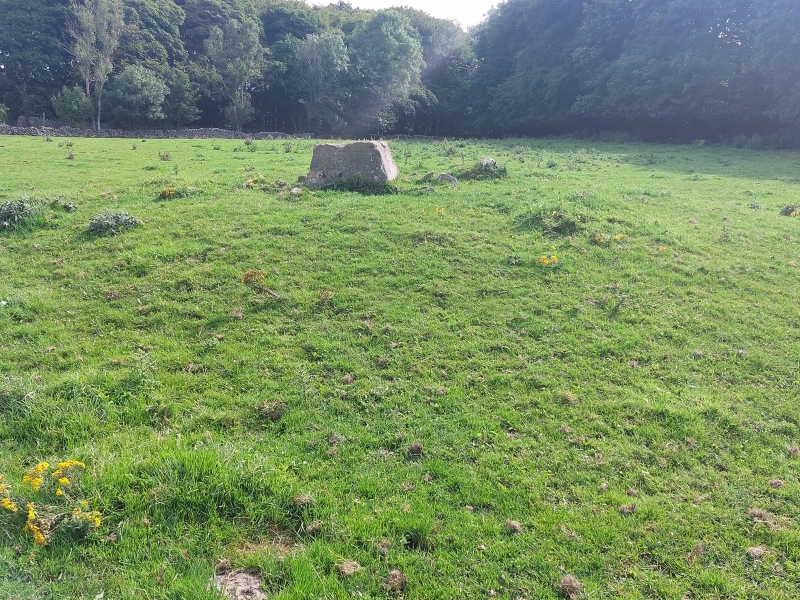
Wind Low bowl barrow is situated north of Wye Dale on the limestone plateau of
Derbyshire. The monument includes the barrow and the base of a medieval
standing cross within a single constraint area.
The barrow comprises a mound currently measuring 16m by 12m by 0.7m high.
Previously it had a diameter of c.18.5m and was somewhat higher, but has been
degraded by ploughing at some time after Thomas Bateman's partial excavation
of the site in 1846. Bateman discovered a primary central cist containing the
disturbed remains of three adult and two child skeletons, burnt bones, pot
sherds and flint, part of a shale bracelet and a necklace of jet and ivory.
The cist has since been removed, probably when the barrow was ploughed, and a
kerb of limestone blocks also noted by Bateman is no longer visible. The
finds indicate a Bronze Age date for the barrow which was also re-used at a
much later date for the setting of a medieval standing cross. The base of the
cross currently stands on the mound and consists of a dressed sandstone block
with a socket hole in the top.
MAP EXTRACT
The site of the monument is shown on the attached map extract.
It includes a 2 metre boundary around the archaeological features,
considered to be essential for the monument's support and preservation.
Source: Historic England
Bowl barrows, the most numerous form of round barrow, are funerary monuments
dating from the Late Neolithic period to the Late Bronze Age, with most
examples belonging to the period 2400-1500 BC. They were constructed as
earthen or rubble mounds, sometimes ditched, which covered single or multiple
burials. They occur either in isolation or grouped as cemeteries and often
acted as a focus for burials in later periods. Often superficially similar,
although differing widely in size, they exhibit regional variations in form
and a diversity of burial practices. There are over 10,000 surviving bowl
barrows recorded nationally (many more have already been destroyed), occurring
across most of lowland Britain. Often occupying prominent locations, they are
a major historic element in the modern landscape and their considerable
variation of form and longevity as a monument type provide important
information on the diversity of beliefs and social organisations amongst early
prehistoric communities. They are particularly representative of their period
and a substantial proportion of surviving examples are considered worthy of
protection.
Although the centre of Wind Low bowl barrow has been disturbed and the barrow
is somewhat degraded by ploughing, the edges are reasonably well preserved and
the barrow will contain further archaeologically significant remains.
Source: Historic England
Books and journals
Barnatt, J, The Peak District Barrow Survey (1989), (1989)
Barnatt, J, The Peak District Barrow Survey (1989), (1989)
Bateman, T, Vestiges of the Antiquities of Derbyshire, (1849)
Marsden, B M, The Burial Mounds of Derbyshire , (1977)
Other
Thesis, Lewis, GD, The Bronze Age in the Southern Pennines, (1970)
Source: Historic England
Other nearby scheduled monuments