Approximate Location Map
Large Map »
This site is entirely user-supported. See how you can help.
Latitude: 53.7065 / 53°42'23"N
Longitude: -0.206 / 0°12'21"W
OS Eastings: 518513.753412
OS Northings: 424833.933223
OS Grid: TA185248
Mapcode National: GBR WT0L.62
Mapcode Global: WHHH4.T32C
Entry Name: Paull Holme moated site and tower
Scheduled Date: 23 March 1927
Last Amended: 21 January 1994
Source: Historic England
Source ID: 1007875
English Heritage Legacy ID: 21175
County: East Riding of Yorkshire
Civil Parish: Paull
Traditional County: Yorkshire
Lieutenancy Area (Ceremonial County): East Riding of Yorkshire
Church of England Parish: Paull St Andrew and St Mary
Church of England Diocese: York
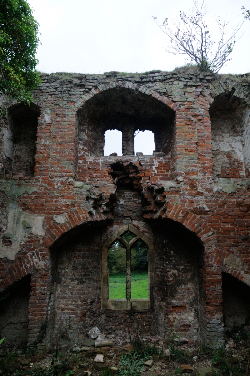
The monument is the site of the medieval moated manor of Paull Holme. It
includes a dry rectangular moat surrounding a raised island measuring
190 metres north to south and 100 metres east to west. Three arms of the moat
are visible, the northern, eastern and southern. The southern arm has, however
been re-dug and incorporated within later field drains which are still in use.
The western arm of the moat has been completely infilled. The island
appears, from 19th century maps, to have been sub-divided by a ditch which ran
from east to west across the site; this feature has also been infilled. To
the north of this feature, earthworks visible on the island are the remains of
a medieval manor house which formerly occupied the site. A brick tower also
occupies this side of the moated site. It is late 15th century in date, and
has a tunnel-vaulted basement with two upper storeys above. The tower is in a
ruinous condition and is roofless.
The tower is a Grade I listed building.
The manor was the home of the Holme family. The brick tower was an element of
a brick house built during the 15th century. This house continued in use until
the 19th century, when it was robbed to provide building materials for new
buildings away from the moated site. In 1871 the tower was converted into a
gazebo by Colonel Bryn Holme. Since 1900 the tower has fallen into ruin.
MAP EXTRACT
The site of the monument is shown on the attached map extract.
Source: Historic England
Around 6,000 moated sites are known in England. They consist of wide ditches,
often or seasonally water-filled, partly or completely enclosing one or more
islands of dry ground on which stood domestic or religious buildings. In some
cases the islands were used for horticulture. The majority of moated sites
served as prestigious aristocratic and seigneurial residences with the
provision of a moat intended as a status symbol rather than a practical
military defence. The peak period during which moated sites were built was
between about 1250 and 1350 and by far the greatest concentration lies in
central and eastern parts of England. However, moated sites were built
throughout the medieval period, are widely scattered throughout England and
exhibit a high level of diversity in their forms and sizes. They form a
significant class of medieval monument and are important for the understanding
of the distribution of wealth and status in the countryside. Many examples
provide conditions favourable to the survival of organic remains.
Despite limited in-filling and re-use of the moat, this site survives
reasonably well and will retain significant archaeological remains of
buildings which originally occupied the island. The later brick tower is also
an important survival and other buried remains of the brick house, of which it
was an element, will exist on the island.
Source: Historic England
Books and journals
Boyle, J R, The Early History of the Town and Port of Hedon, (1875), 94
Le Patourel, H E J, Moated site of Yorkshire, (1973), 115
Pevsner, N, The Buildings of England: Yorkshire - York and the East Riding, (1972), 325
Pevsner, N, The Buildings of England: Yorkshire - York and the East Riding, (1972), 325
Poulson, G, History and Antiquities of Holderness, (1841), 493
Sheahan, , Whellan, , History and Topography of York And The East Riding, (1856), 343
Brooks, F W, 'Journal of the British Archaeological Association' in Journal of the British Archaeological Association, (1939)
Ryder, P F, Coleman, S, 'The East Riding Archaeologist' in Paull Holme Tower, (1983), 85-87
Ryder, P F, 'The East Riding Archaeologist' in The East Riding Archaeologist, (1983), 85
Source: Historic England
Other nearby scheduled monuments