Approximate Location Map
Large Map »
This site is entirely user-supported. See how you can help.
Latitude: 54.405 / 54°24'17"N
Longitude: -2.6026 / 2°36'9"W
OS Eastings: 360982.170921
OS Northings: 501224.412063
OS Grid: NY609012
Mapcode National: GBR BK8H.BQ
Mapcode Global: WH93P.ZJVX
Entry Name: Low Borrowbridge Roman fort
Scheduled Date: 26 June 1924
Source: Historic England
Source ID: 1007240
English Heritage Legacy ID: CU 33
County: Cumbria
Civil Parish: Tebay
Traditional County: Westmorland
Lieutenancy Area (Ceremonial County): Cumbria
Church of England Parish: Grayrigg
Church of England Diocese: Carlisle
Low Borrowbridge Roman fort and civilian settlement, 405m north west of Salterwath Bridge.
Source: Historic England
This record has been generated from an "old county number" (OCN) scheduling record. These are monuments that were not reviewed under the Monuments Protection Programme and are some of our oldest designation records.
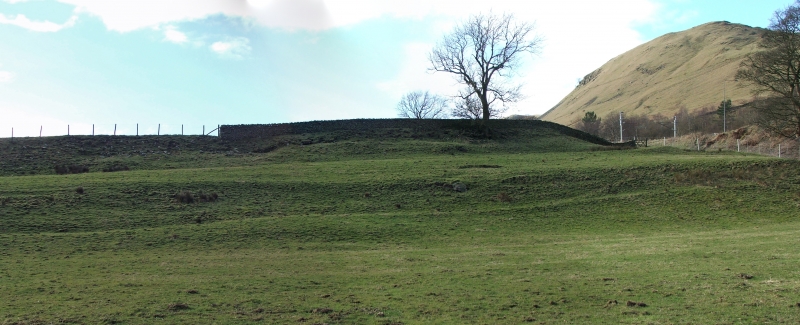
The monument includes the remains of a fort and its civilian settlement (or vicus) of Roman date, situated on a spur formed by the River Lune and Barrow Beck and contained within three separate areas of protection. The fort is aligned roughly north-south and is parallelogram-shaped in plan measuring approximately 140m by 105m. The fort is surrounded by a rampart and multiple ditches which are partially preserved as earthworks. The majority of the rampart stands to a height of 1.5m and is clearly visible on all but the south side. The rampart is mainly visible as an earthen bank but partial excavation has shown the defences to include sandstone, limestone and slate walling, the remains of which survive beneath the turf. On the north side there is a double ditch with traces of a counterscarp whilst on the west and south sides there are double ditches with an average width of 7m and with feint traces of additional ditches, especially in the south west corner. There is no clear earthwork remains of a ditch on the east side, however, there are outworks in the form of a 1m high and 2m wide earthen bank which runs above the River Lune parallel to the east side of the fort at a distance of 50m before turning to join the main ditch system at the north east corner of the fort. The ditches and ramparts on the west side of the fort are interrupted by a 1.8m wide single portal gateway with the stone foundations of the gateway protruding through the turf. To the south of the fort are the remains of its civilian settlement, which are preserved as cropmarks and below ground archaeological deposits, the most significant of which include a bath house built in two phases and a cemetery, both of which were used during the 2nd to 3rd centuries AD. Several excavations have demonstrated the significant extent of archaeological remains related to both the fort and its vicus. Excavations in 1950 indicated that the fort was occupied during much of the Roman occupation of Britain with evidence of multiple episodes of destruction and reconstruction. The lower parts of the rampart and wall are understood to be dated to the Hadrianic period whilst the upper parts date to the Severan period.
Source: Historic England
Roman forts served as permanent bases for auxiliary units of the Roman Army. In outline they were straight sided rectangular enclosures with rounded corners, defined by a single rampart of turf, puddled clay or earth with one or more outer ditches. Although built and used throughout the Roman period, the majority of forts were constructed between the mid first and mid second centuries AD. Some were only used for short periods of time but others were occupied for extended periods on a more or less permanent basis. In the earlier forts, timber was used for gateways, towers and breastworks. From the beginning of the second century AD there was a gradual replacement of timber with stone. Roman forts are rare nationally and are extremely rare south of the Severn Trent line. As one of a small group of Roman military monuments, which are important in representing army strategy and therefore government policy, forts are of particular significance to our understanding of the period. All Roman forts with surviving archaeological potential are considered to be nationally important.
The remains of Low Borrowbridge Roman fort and civilian settlement are extensive and well-preserved. Partial excavation has shown the monument to contain widespread archaeological deposits which provide important information on the date and nature of use of the site. The monument provides important insight into a wide range of aspects of civilian and military life during the Roman occupation of Britain.
Source: Historic England
Other
PastScape Monument No:- 13265 (fort and bath house), 1025913 (bath house)
Source: Historic England
Other nearby scheduled monuments