Approximate Location Map
Large Map »
This site is entirely user-supported. See how you can help.
Latitude: 51.8699 / 51°52'11"N
Longitude: -2.6182 / 2°37'5"W
OS Eastings: 357532.202992
OS Northings: 219221.256968
OS Grid: SO575192
Mapcode National: GBR FQ.S76H
Mapcode Global: VH86P.K8QB
Entry Name: Dry Arch Bridge 300yds (270m) NE of St Giles' Church
Scheduled Date: 8 May 1975
Source: Historic England
Source ID: 1005349
English Heritage Legacy ID: HE 193
County: Herefordshire,
Civil Parish: Goodrich
Traditional County: Herefordshire
Lieutenancy Area (Ceremonial County): Herefordshire
Church of England Parish: Goodrich and Welsh Bicknor
Church of England Diocese: Hereford
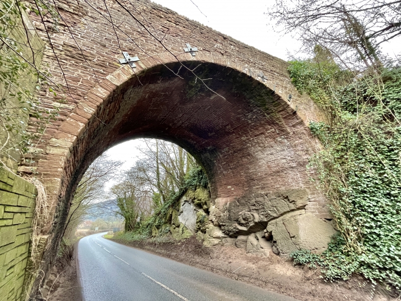
Single span bridge 390m south west of Priory Farm.
Source: Historic England
This record was the subject of a minor enhancement on 21 May 2015. This record has been generated from an "old county number" (OCN) scheduling record. These are monuments that were not reviewed under the Monuments Protection Programme and are some of our oldest designation records. As such they do not yet have the full descriptions of their modernised counterparts available. Please contact us if you would like further information.
This monument includes a single span bridge situated on a sloping ridge which forms the western valley side of the River Wye. The bridge is known locally as ‘Dry Arch Bridge’ and with the aid of a rock cut cutting enables one road to pass beneath another at right angles. The bridge is fully standing and stone built and there is a flight of 33 steps which connect the upper road with the lower road for use by pedestrians. The bridge carries a road still in use by vehicles (the Goodrich-Welsh Bicknor road) across another road similarly employed (the B4229) and is described by the county as being ‘an excellent example of very early vehicle grade separation’ or a simple ‘fly-over’. The bridge was built in 1825-8.
Source: Historic England
The single span bridge 390m south west of Priory Farm may actually be one of the earliest examples of a bridge specifically built to carry a minor road across a more major one without the interruption of the busier road by a road junction. It did, however, allow pedestrian traffic to cross from one ‘lane’ to the other three dimensionally without a lengthy diversion. It remains in active use and presumably set the scene for all major road traffic intersections which were to follow and as such represents an early example of congestion alleviation on the road network which is so pivotal to modern road travel.
Source: Historic England
Other
PastScape 109634
Source: Historic England
Other nearby scheduled monuments