Approximate Location Map
Large Map »
This site is entirely user-supported. See how you can help.
Latitude: 52.3672 / 52°22'1"N
Longitude: -2.7229 / 2°43'22"W
OS Eastings: 350876.233697
OS Northings: 274596.576416
OS Grid: SO508745
Mapcode National: GBR BK.RY2G
Mapcode Global: VH843.RRDN
Entry Name: Ludlow Castle
Scheduled Date: 8 February 1915
Last Amended: 29 September 2014
Source: Historic England
Source ID: 1004778
English Heritage Legacy ID: SA 7
County: Shropshire
Civil Parish: Ludlow
Built-Up Area: Ludlow
Traditional County: Shropshire
Lieutenancy Area (Ceremonial County): Shropshire
Church of England Parish: Ludlow St Laurence
Church of England Diocese: Hereford
Ludlow Castle, the standing structural, earthwork and buried remains of an enclosure castle, converted into a tower keep castle in the C12.
Source: Historic England
PRINCIPAL ELEMENTS
Ludlow Castle, the standing structural, earthwork and buried remains of an enclosure castle, converted into a tower keep castle in the C12.
DESCRIPTION
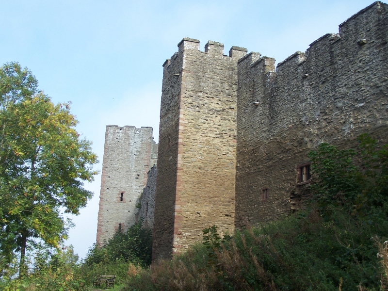
The castle is defined on its northern and western sides by a substantial bluff created by the River Teme. In its initial phase, beginning circa 1075, the southern and eastern sides of the castle were bounded by a deep, steep-sided rock-cut ditch, about 25m wide. The resulting elliptical enclosure, which later became the INNER BAILEY of the enlarged castle, measures approximately 70m by 80m. Rock quarried from the ditch and the bluff was used to build much of the adjacent curtain wall, the four adjoining mural towers and the gatehouse. Three of the four towers are open at the back and would originally have contained wooden scaffolding supporting look-out and fighting platforms. The fourth tower, known as the POSTERN TOWER, on the western side of the enclosure, has small ground-floor postern doorways on its north and east sides. All these buildings are thought to have been constructed by 1115.
Also originating in the first building phase of the castle is the gatehouse, situated at the south-eastern part of the enclosure; this is rectangular in plan and was originally three storeys in height. Remaining in the ground-floor of the building is part of a wall arcade, thought to be late-C11, with ornamented capitals. In the early C12 a fourth storey was added to provide more domestic accommodation, thus converting the gatehouse into a tower keep, known as the GREAT TOWER. In the later C12 the original gatehouse entrance passage was blocked (the location of the former arch remains visible on the south elevation) and an archway was cut through the adjacent part of the curtain wall to the north-east, reached by a stone bridge. This archway was partially infilled and a smaller arch constructed in the C14. Within the ditch, adjacent to the original entrance passage, are the remains of abutments which supported a timber bridge. Access to the upper floors is by a spiral stair to the east, reached by an ornamented doorcase, the Tudor arch having a trefoiled lintel flanked by cusped panelling and trefoiled lintel, which also gives access to rooms in the Judges’ Lodgings (see below). On the first floor, the hall, with a chamber and garderobe to the west. In the second half of the C15 the north wall of the Great Tower was rebuilt and internal floors added to create new rooms lit by enlarged windows.
In the C12 and C13, the construction of a walled enclosure in the south-west section of the inner bailey, adjoining the Great Tower, known as the INMOST BAILEY or ‘Great Court', provided greater security and privacy for those living in the Great Tower. Within this court a well was dug to provide a reliable source of water; the well, surrounded by a low wall, is reputed to be about 36.6m deep but was partially filled in 1908 and is now only about 18.3m deep.
Located in the north-eastern sector of the elliptical enclosure of the inner bailey are the remains of the CHAPEL OF ST MARY MAGDALENE. This was built in the first half of the C12, probably by Gilbert de Lacy, and was remodelled in the C16, probably in two phases. In the first phase, thought to have been undertaken circa 1502 for the installation of Arthur, Prince of Wales, a first floor was inserted in the circular nave, together with additional openings, including a first-floor doorway which gave access to a passage linking the chapel with the Great Chamber Block to the north. In the second phase, during the presidency of the Council in the Marches of Sir Henry Sidney (1560-86), the original presbytery and chancel were taken down and a new chancel, or chapel, built, stretching as far as the curtain wall. The crenellated circular nave, which measures 8.3m in diameter internally, survives to its full height as a roofless shell, and contains much original carving to the round-headed order arches of the door openings, with chevron and billet mouldings, and to the internal blind arcade with a variety of capitals and moulded arches. The original presbytery and apse were found when the chapel was partially excavated between 1904 and 1908, and survive as buried features within the reduced walls of the late-C16 structure.
In the second half of the C12 a large OUTER BAILEY was created to the south and east of the original castle. This quadrupled the size of the castle and led to the truncation of some of the streets in the Dinham area of the town. The entranceway into the castle was now from the east, through the town’s newly established market place. Originally, the outer bailey defences consisted of a curtain wall, with two adjoining rectangular mural towers, a two-storeyed GATEHOUSE and an associated barbican, as well as a substantial outer ditch, which defined the southern and eastern sides of this enclosure; although largely infilled during the landscaping of the area in the late C18, some evidence is likely to survive as a buried feature. A documentary source indicates that in the late C16, as part of the major repair and rebuilding programme undertaken by Sir Henry Sidney, a new stone bridge was built; the remains of this later bridge, together with the evidence of earlier bridges, will survive as buried features. Of the two mural towers, only the one to the north of the gateway survives as a standing structure. This, together with the adjacent section of the curtain wall forms part of the CASTLE HOUSE built in the C18; this building is listed at Grade I and is excluded from the scheduling. Protruding from the curtain wall defining the western side of the outer bailey are the remains of a semi-circular tower, known as MORTIMER’S TOWER, possibly built in the early C13. This originally consisted of a ground-floor entrance passage, with two floors above, and was used as the postern entrance to the outer bailey until the 15th century. Another semi-circular tower built next to the curtain wall, on the eastern side of the outer bailey to the south of the gatehouse, no longer survives as a standing structure, but its foundations are believed to survive as buried features. On the western side of the outer bailey, to the south of the inner bailey ditch, there is an UNDERGROUND CHAMBER that was used as an icehouse, but may have been built as a magazine for the storage of arms and ammunition.
In the south-west corner of the outer bailey are the remains of ST PETER’S CHAPEL, originally a free-standing rectangular structure, founded by Roger Mortimer to celebrate his escape from the Tower of London in 1324, following his rebellion against Edward II. The chapel served as the Court House and offices of the Council in the Marches, for which an adjacent building to the west was constructed. The south-east corner of the chapel is now attached to a wall which completes the enclosure of the outer bailey’s south-west corner. In the north wall of the chapel is a blocked two-light window, enlarged at the bottom when a floor was inserted for the court house; a second original window towards the eastern end now contains a first-floor blocked doorway.
At the end of the C13 or in the early C14 an extensive building programme was initiated, replacing existing structures within the inner bailey with a grand new range of domestic buildings, built along the inside of the north section of the Norman curtain wall. The construction of these new buildings indicates the changing role of Ludlow Castle from military stronghold to a more comfortable residence and a seat of political power, reflecting the more peaceful conditions in the region following the conquest of Wales by Edward I. The first buildings to be completed were the GREAT HALL and the adjoining SOLAR BLOCK (private apartments). The Great Hall, which was used for ceremonial and public occasions, consisted of a first floor over a large undercroft, reached through a moulded pointed arch in the south elevation. The Hall was lit on both south and north sides by three pointed-arched windows with sunk chamfers and ‘Y’ tracery formed of paired cusped trefoil-headed lights, under hoodmoulds; these originally had seats, now partially surviving. The central south window was converted to a fireplace, replacing the louver which formerly covered the open fire towards the east of the Hall, its position indicated by elaborate corbels. At the west end, a series of openings lead into the Solar Block, only one of these (that to the north) being of the primary phase. The Solar Block is thought to have been begun as a two-storey building, and raised to three storeys shortly afterwards, at which time the adjacent NORTH-WEST TOWER was raised, with the new CLOSET TOWER being built in the angle between the two. Each of the three floors of the Solar Block extended into the North-West Tower, with each being linked to a room in the Closet Tower. All three floors of the Solar were heated, the ground floor having a fireplace which originally had a stone hood; the first-floor room has hooded fireplace, on nearly triangular-sectioned jambs; the room above has a plainer hooded fireplace. The windows include original openings with ‘Y’ tracery and trefoil-headed lights, similar to those in the Hall, and a ground-floor mullioned window probably dating from the late C16. The Hall and Solar were served by a kitchen and pantry built against the wall of the inmost bailey, the footings of which survive.
In the early C14 two additional buildings containing more private apartments were constructed by Richard Mortimer. The three-storeyed GREAT CHAMBER BLOCK was built in about 1320 next to the Great Hall to balance the Solar Block to the west of the Hall. The connecting four-storeyed GARDEROBE TOWER, which projects from the curtain wall of the inner bailey, was also probably built about the same time. As in the Hall and Solar blocks, the floors are now lost but features in the walls remain to indicate layout and function. The main entrance to this block is through a recessed doorway in the south-west corner, with a pointed two-light window above. The undercroft was heated, and is lit by two two-light windows with stone side seats in the south wall. The tracery of the eastern of these windows has been lost. The first-floor main room, or ‘Great Chamber’, contains a grand hooded fireplace carried on a fourfold series of corbels; to either side of the fireplace are large head corbels with leafwork. The Tudor transomed and mullioned window probably replaced an earlier window. The upper room also has a large hooded fireplace, and was lit principally by a large trefoil-headed window with head-stopped hoodmould in the southern wall.
Following the establishment of the headquarters for the Council in the Marches at Ludlow, new buildings were constructed and many existing buildings changed their use. Within the inner bailey the main room in the Great Chamber Block became the council chamber, with additional chambers above. A new adjoining residential block, now called the TUDOR LODGINGS, was built to the east. This replaced earlier structures of which traces remain, and consisted of two sets of lodgings both being of three storeys with attic rooms above. The south wall of this block cuts across openings in the east wall of the Great Chamber Block. Between the lodgings, projecting from the south wall, is a circular stair tower, entered through an ogee-headed arch. The windows in the south elevation are mullioned; several have been blocked. In the north wall of the western lodging, at ground-floor level, is an opening with double trefoil head, having a divided light above. Otherwise, the features of this range are plain, with pointed door openings, and straight lintels to fireplaces. As the power of the Council grew, further domestic accommodation was needed. To the east of the entrance within the inner bailey, a three-storeyed range, known as the JUDGES LODGINGS, was completed in 1581. On the south side, this building extends the curtain wall upwards, with two gables, and piercing for fenestration, the earlier arched entrance to the inner bailey becoming visually part of the newer building, with rooms above; stone arms set immediately over the archway dated 1581 commemorate the Presidency of the Council of Sir Henry Sidney. Rooms set above the arch leave a gate-passage leading through a second archway to the inner bailey, and giving access to both the Great Keep and the Judges’ Lodgings. The rooms above the gate-passage appear to have been accessed by the embellished Tudor-arched doorway in the Keep at the north end of the passage. The north side of the Judges’ Lodgings, within the inner bailey, has a polygonal stair turret (which originally had a pyramidal roof), with mullioned and transomed eight-light windows set regularly to either side. Within, some indication is given of the arrangement and appearance of the rooms by the survival of numerous fireplaces of red sandstone backed by brick set in herringbone pattern. The adjoining building to the east, originally two-storeyed, is thought to date from the C17. A number of ancillary buildings, such as a laundry (to the east of the Judges’ Lodgings), and a brewhouse (in the inmost bailey), were also constructed at the castle about this time, though these no longer have upstanding remains. The south-west corner tower, enclosed by the inmost bailey, became known as the OVEN TOWER, a large oven having been installed at this time at ground-floor level, with residential rooms above. In the outer bailey, to the south of the gatehouse, are the remains of the PORTER’S LODGE, built in 1522, which now contains the castle shop. The PRISON, adjoining to the south, was also built in 1522. The STABLE BLOCK, adjoining further south, was completed in 1597, and does not have internal features.
In the late C18, when the castle was leased to the Earl of Powis, the establishment of paths included the creation of a sunken walkway through the south-western portion of the outer bailey and two arches through the adjacent parts of the curtain wall. In the area immediately to the south of the castle, ground disturbance and landscaping associated with the construction of Dinham House and adjacent outbuildings have significantly affected the preservation of the south-western part of the outer bailey ditch and this area is therefore not included in the scheduling.
EXTENT OF SCHEDULING: the boundary of the scheduled area follows the line of the castle walls; at the north-east corner of the castle walls it extends from the castle walls to the boundary with Ludlow College, following this wall southwards to the roadway leading from Castle Square to the Gatehouse. It crosses this roadway and extends along a line within the eastern boundary of Castle Gardens towards the south-east corner, and then follows the line of the gardens westwards to the boundary with Dinham House, and then northwards to the castle wall. There is a buffer zone of three metres along the line of the castle walls to the west and north, from the south-west corner of the castle walls to the boundary with Ludlow College.
EXCLUSIONS: the C18 Castle House, which is listed at Grade I, is excluded from the scheduling. In addition, the monument now has a number of later features, which do not form part of the scheduling. These include all modern surfaces, fence posts, railings, flood lights and the concrete bases on which they stand, interpretation signage, litter bins and park furniture, a greenhouse and sheds together with the concrete plinths on which they stand, timber platforms and walkways within the buildings, timber steps, protective screens, rails, grilles and handrails, and the modern fixtures within the Porter's Lodge (now the castle shop). As noted above the C18 Castle House is excluded from the scheduling, together with the raised flight of stone steps providing access to its garden and the southern boundary wall of Castle House, and the adjacent mains electricity unit. In the Castle Gardens, all modern surfaces, fences, litter bins and park furniture together with concrete bases, and a sculpture are excluded from the scheduling. Also excluded is the boundary wall defining the eastern extent of the grounds of Dinham House and the outbuilding adjacent to Dinham House. The ground beneath all these features is, however, included.
Source: Historic England
Ludlow Castle, the standing structural, earthwork and buried remains of an enclosure castle, converted into a tower keep castle in the C12, is scheduled for the following principal reasons:
*Historical: as one of England's finest and best preserved castles, which played an important role particularly as seat of the President of the Council of the Marches, and demonstrates significant phases of development between the C11 and C16;
*Archaeological potential: the site retains buried remains which have the potential to increase our knowledge and understanding of the castle, and of this building type.
Source: Historic England
Books and journals
Cathcart-King, D J, Castellarium Anglicanum, (1983)
Goodall, J, The English Castle, 1066-1650, (2011)
H M Colvin, D R Ransome, The History of the KIng's Works, vol 3, (1975)
J Kenyon, , The Castles in Wales and the Marches, Essays in honour of D J Cathcart King, (1987)
Pevsner N, , Newman, J, The Buildings of England: Shropshire, (2006)
R Allen Brown, H M Colvin, The History of the King's Works, vol 2, (1963)
Shoesmith, R, Johnson, A (eds), Ludlow Castle. Its History and Buildings, (2000)
W. H. St John Hope, , 'Archaeologia' in The Castle of Ludlow, , Vol. 61, (1908)
Other
Archaeological Investigations Ltd, Hereford archaeology series, 1991,
Pastscape Monument No. 111057,
Shropshire HER 01176,
Source: Historic England
Other nearby scheduled monuments