Approximate Location Map
Large Map »
This site is entirely user-supported. See how you can help.
Latitude: 50.5227 / 50°31'21"N
Longitude: -5.0279 / 5°1'40"W
OS Eastings: 185469.0275
OS Northings: 73592.2902
OS Grid: SW854735
Mapcode National: GBR ZG.Q2H4
Mapcode Global: FRA 07CP.11Z
Entry Name: Three promontory forts south of Trethias Island
Scheduled Date: 29 January 1975
Source: Historic England
Source ID: 1004234
English Heritage Legacy ID: CO 844
County: Cornwall
Civil Parish: St. Merryn
Traditional County: Cornwall
Lieutenancy Area (Ceremonial County): Cornwall
Church of England Parish: St Merryn
Church of England Diocese: Truro
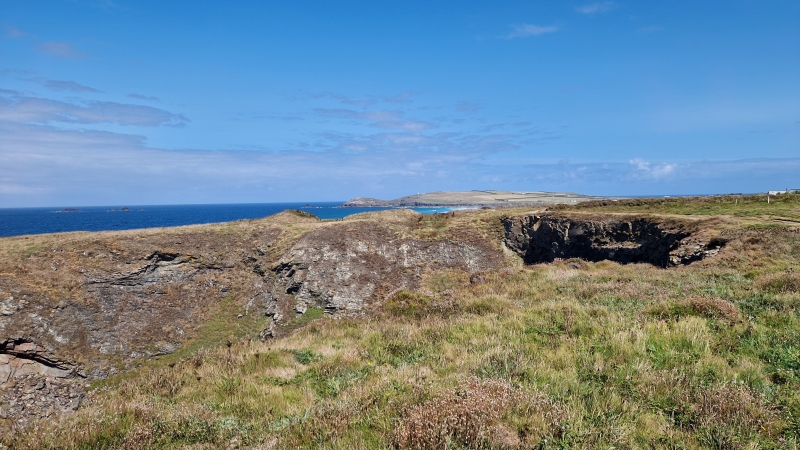
The monument includes three promontory forts, situated on three parallel small coastal headlands between Winecove Point, Pepper Cove and Warren Cove. All three are defended by steep cliffs above narrow coves except to the landward (east) side where they are defined by lines of ditches with or without ramparts across the narrowest points of the respective headlands. The southernmost has three well-defined and well-spaced ditches, two of which are rock-cut. Only the middle ditch has an accompanying rampart bank. The inner ditch has a centrally placed causeway, and the outer two ramparts have staggered entrances. The central fort has two ramparts with rock-cut ditches and centrally placed entrances. The northern fort is defined by a single partially infilled rock-cut ditch of up to 3m deep with a rampart of up to 0.8m high. It has a central entrance. The area of hinterland between the three forts is also included in the scheduling.
Sources: HER:-
PastScape Monument No:-429505, 429510 and 429519
Source: Historic England
Promontory forts are a type of hillfort in which conspicuous naturally defended sites are adapted as enclosures by the construction of one or more earth or stone ramparts placed across the neck of a spur in order to divide it from the surrounding land. Coastal situations, using headlands defined by steep natural cliffs, are common while inland similar topographic settings defined by natural cliffs are also used. The ramparts and accompanying ditches formed the main artificial defence, but timber palisades may have been erected along the cliff edges. Access to the interior was generally provided by an entrance through the ramparts. The interior of the fort was used intensively for settlement and related activities, and evidence for timber- and stone- walled round houses can be expected, together with the remains of buildings used for storage and enclosures for animals. Promontory forts are generally Iron Age in date, most having been constructed and used between the sixth century BC and the mid-first century AD. They are broadly contemporary with other types of hillfort. They are regarded as settlements of high status, probably occupied on a permanent basis, and recent interpretations suggest that their construction and choice of location had as much to do with display as defence. Promontory forts are rare nationally with less than 100 recorded examples. They are relatively rare and important for understanding of the nature of social organisation in the later prehistoric period. The three promontory forts south of Trethias Island are unusual because they occupy a series of closely spaced headlands and all are defended in subtly different ways. They will contain archaeological and environmental evidence relating to their construction, longevity, relationship, development, relative chronologies, social organisation, territorial significance, trade, domestic arrangements, function and overall landscape context.
Source: Historic England
Other nearby scheduled monuments