Approximate Location Map
Large Map »
This site is entirely user-supported. See how you can help.
If Google Street View is available, the image is from the best available vantage point looking, if possible, towards the location of the monument. Where it is not available, the satellite view is shown instead.
Latitude: 53.3183 / 53°19'5"N
Longitude: -0.7011 / 0°42'4"W
OS Eastings: 486621.2199
OS Northings: 380933.4983
OS Grid: SK866809
Mapcode National: GBR RZK2.06
Mapcode Global: WHGHJ.6VCJ
Entry Name: The medieval bishop's palace and deer park, Stow Park
Scheduled Date: 13 June 1973
Last Amended: 24 January 2001
Source: Historic England
Source ID: 1019229
English Heritage Legacy ID: 22768
County: Lincolnshire
Civil Parish: Stow
Traditional County: Lincolnshire
Lieutenancy Area (Ceremonial County): Lincolnshire
Church of England Parish: Stow St Mary
Church of England Diocese: Lincoln
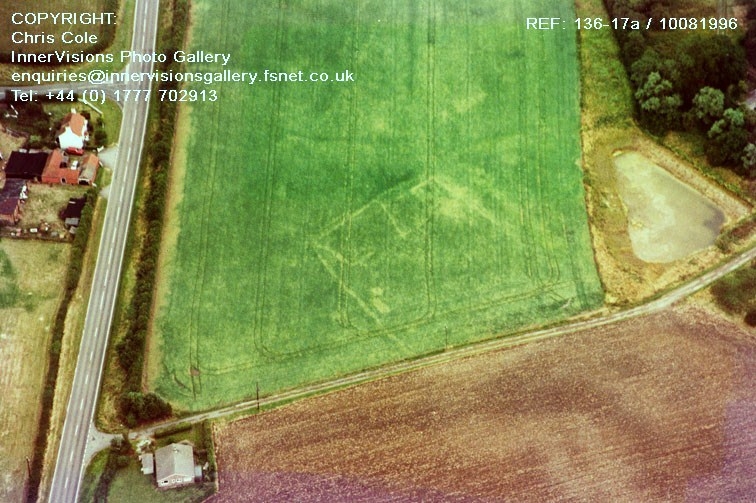
The monument includes the buried and earthwork remains of a medieval palace of
the Bishops of Lincoln, together with associated water features and deer park,
situated at Stow Park, 1.9km south west of Stow. The remains of the bishop's
palace and deer park lie in three separate areas of protection. Although the
palace is first referred to in documentary sources of the late 12th century,
episcopal ownership of the manor is likely to date back to at least the
previous century when the bishop founded the Church of St Mary at Stow. King
John visited the manor in 1200, and in 1336 a royal licence was obtained to
crenellate the dwelling house. During the 13th and 14th centuries it was one
of the principal residences of the Bishops of Lincoln. In the mid-16th
century, however, Bishop Holbeach transferred the manor into private hands. By
the late 18th century the buildings were in ruins, and following the removal
of building materials, a new farmhouse with outbuildings, called Moat Farm,
was constructed on the site.
The moated site on which the palace stood, together with its fishponds and
other water-control features, lies in a prominent position on gently sloping
ground overlooking the Trent valley to the south and west. The moat is
constructed on the south side of a west-flowing stream, to which it is
connected by a linear channel running eastwards from its north eastern corner.
Adjacent to the north is a series of broad depressions, partly embanked,
representing ponds constructed along the course of the stream. Although the
easternmost pond has been partly infilled, and the dam retaining it lowered by
modern ploughing, remains of the pond will survive as buried archaeological
deposits. The central depression, immediately to the north of the moated
site, is now partly occupied by a modern pond; the dam on its western side,
which stands to a height of about 2m, carries a causeway which is believed to
represent the principal medieval access to the palace. An area of raised
ground adjacent to the western side of the causeway may indicate the position
of a gatehouse. The dammed ponds may thus be seen to have formed an ornamental
water feature, enhancing the main approach to the medieval palace, as well as
being used for keeping fish; documentary sources suggest that they also served
as a swannery.
Adjacent to the south east of these water features, and approximately 30m east
of the moated site, is a group of much smaller ponds, linked to and aligned
with the east-west channel which feeds into the moat. The largest of these
ponds measures about 35m by 9m and is 0.5m in depth; a southerly extension at
its eastern end, about 14m in length, may have originated as a separate pond.
Adjacent to its western end is another pond about 10m square. This group of
ponds is believed to represent a series of breeding tanks for raising fish,
which would subsequently be transferred into the larger ponds.
The moated site, upon which the principal buildings of the palace were
located, lies adjacent to the south of the main water features. The moated
island, which is raised about 2m above the surrounding ground level, is
subrectangular in plan, measuring about 75m by 85m. Although no standing
remains of the medieval palace are now visible above ground, the buried
remains of the domestic and service buildings of the palace will survive below
it. The island is surrounded by a substantial moat, 3m in depth and now
largely dry, which is crossed by the principal causeway on the north side, and
by a narrower causeway near the northern end of the east side, which may be
later in date. The moat is in turn surrounded by an outer bank; on the north
side it separates the moat from the adjacent water features, and on the east
it is visible as a substantial earthwork up to 20m wide. On the south side,
and on the west where it extends northwards to serve as the westernmost dam
among the adjacent water features, the bank has been reduced by modern
ploughing and now survives as a low earthwork about 0.5m high.
The medieval deer park associated with the palace formerly occupied an area of
about 275ha extending southwards from the moated site. The surviving remains
of the park pale are protected in two areas, 1.5km and 1km to the south west
and south east of the moated site respectively. The south western part of the
park pale survives as a linear bank about 8m in width; along its eastern,
inner, side is a broad linear ditch, now partly infilled, which is visible as
a dry depression about 1.5m below the narrower inner counterscarp bank which
runs in turn along its eastern side. The surviving earthworks thus extend for
a length of about 770m, including the south western corner of the deer park.
The south eastern part of the park pale also survives as a linear bank about
8m wide and 110m long, although the inner ditch has been replaced by a modern
drain and is no longer evident. The earthworks protected in these two areas
represent the only surviving parts of a formerly extensive landscape feature.
All fences, gates, and all standing buildings and modern surfaces at Moat Farm
are excluded from the scheduling, although the ground beneath them is
included.
MAP EXTRACT
The site of the monument is shown on the attached map extract.
Source: Historic England
Bishops' palaces were high status domestic residences providing luxury
accommodation for the bishops and lodgings for their large retinues; although
some were little more than country houses, others were the setting for great
works of architecture and displays of decoration.
Bishops' palaces were usually set within an enclosure, sometimes moated,
containing a range of buildings, often of stone, including a hall or halls,
chapels, lodgings and a gatehouse, often arranged around a courtyard or
courtyards.
The earliest recorded examples date to the seventh century. Many were occupied
throughout the medieval period and some continued in use into the post-
medieval period; a few remain occupied today. Only some 150 bishops' palaces
have been identified and documentary sources confirm that they were widely
dispersed throughout England. All positively identified examples are
considered to be nationally important.
Deer parks were areas of land, usually enclosed, set aside and equipped for
the management and hunting of deer and other animals. They were generally
located in open countryside on marginal land or adjacent to a manor house,
castle or palace. They varied in size between 3ha and 1600ha and usually
comprised a combination of woodland and grassland which provided a mixture of
cover and grazing for deer. Parks could contain a number of features, such as
hunting lodges, park keeper's house, rabbit warrens, fishponds and enclosures
for game, and were usually surrounded by a park pale, a massive fenced or
hedged bank often with an internal ditch. Although a small number of parks
may have been established in the Anglo-Saxon period, it was the Norman
aristocracy's taste for hunting that led to the majority being constructed.
The peak period for the laying-out of parks, between AD 1200 and 1350,
coincided with a time of considerable prosperity amongst the nobility. From
the 15th century onwards few parks were constructed, and by the end of the
17th century the deer park in its original form had largely disappeared. The
original number of deer parks nationally is unknown but probably exceeded
3000. Many of these survive today, although often altered to a greater or
lesser degree. They were established in virtually every county in England,
but are most numerous in the West Midlands and Home Counties. Deer parks were
a long-lived and widespread monument type. Today they serve to illustrate an
important aspect of the activities of medieval nobility and still exert a
powerful influence on the pattern of the modern landscape. Where a deer park
survives well and is well-documented or associated with other significant
remains, its principal features are normally identified as nationally
important.
The remains of the bishop's palace at Stow Park, together with those of its
associated deer park and fishponds, survive well as a series of substantial
earthworks. The palace is well documented and, as a result of detailed
historical research and archaeological survey, its remains are quite well
understood. Buried structural and artefactual remains will provide valuable
information about the construction, layout and use of the palace buildings and
about social and economic activity on the site. As a result of partial
infilling of the moat, ditches and ponds, archaeological deposits relating to
the construction and use of these features will also be preserved; in these
areas, waterlogging will additionally preserve organic remains such as wood
and leather, and environmental material such as seeds and pollen will preserve
unique information about the nature of the landscape in which the palace was
set. The old ground surface sealed beneath the banks forming the park pale
will retain evidence for early land-use prior to the laying-out of the park,
while the earthworks themselves will include buried evidence for structures
which are no longer evident, such as a fence which may have surmounted the
bank. The association of both the deer park and the fishponds with the palace
site will give us an insight into the way in which these features of the
medieval landscape interrelated as components of a high-status establishment.
Source: Historic England
Other nearby scheduled monuments